

Bouddi fishing closure
Fisheries Management (Bouddi National Park – Marine Extension) (Fishing Closure) Notification 2019
under the Fisheries Management Act 1994
I, Natalie Moltschaniwskyj, Acting Deputy Director General Fisheries, with the delegated authority of the Minister and the Secretary in pursuance of sections 227 and 228 of the Fisheries Management Act 1994 (“the Act”), and in pursuance of section 8 and section 11 of the Act, revoke the existing fishing closures for the Bouddi National Park and give notice of the following fishing closure for the Bouddi National Park – Marine Extension.
Commencement and duration
This notification commences on the date it is published in the NSW Government Gazette and will remain in force for 5 years commencing on the date of publication.
Revocation
Pursuant to section 11 of the Act, the Section 8 Notification - Fishing Closure – Bouddi Fishing Closure published in NSW Government Gazette No. 82 of 3 October 2014 at page 3348 and the Section 8 Notification – Commercial Fishing Closure - Bouddi Fishing Closure published in the NSW Government Gazette No. 10 of 6 February 2015 at page 235, are revoked, as are any notifications revived as a result of these revocations.
Fishing closure
Pursuant to section 8 of the Act, a person is prohibited from taking fish from the waters specified in the Schedule, below.
Schedule
| Waters |
|---|
|
The whole of the waters of that part of the South Pacific Ocean adjacent to Bouddi National Park, enclosed within the following boundaries: commencing at the intersection of the mean high water mark at longitude 151°22.858’E at Gerrin Point, the eastern headland of Bullimah Beach, then along a line
drawn generally north-easterly along the mean high water mark on the foreshore of Bouddi National Park, to the intersection of the mean high water mark and longitude 151°25.024’E at Bombi Point, then along a line bearing 135 degrees for 402 metres to a point at or near the coordinate 33°31.548'S, 151°25.208’E
then along a line bearing 239 degrees for 1327 metres to a point at or near the coordinate 33°31.917’S, 151°24.482’E, then along a line bearing 258 degrees for 2534 metres to a point at or near the coordinate 33°32.171'S, 151°22.858’E, then along a line bearing 360 degrees for 402 metres to the point
of commencement. Notes: The coordinates used in this description for the boundaries of the closure are given in degrees and decimal minutes using the Geocentric Datum of Australia 1994 (GDA 94). The boundary for this closure is denoted on 1:25,000 series Topographic Map ‘Broken Bay 9130-1-N’ published by Land & Property Information NSW. |
Map
| Title | Thumbnail |
|---|---|
| Section 8 Commercial - Bouddi Fishing Closure (PDF, 119.82 KB) | 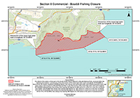 |
Dated this 27th day of September 2019
NATALIE MOLTSCHANIWSKYJ
Acting Deputy Director General Fisheries
Department of Primary Industries
(within the Department of Planning, Industry and Environment)
Note: A fishing closure prohibiting fishing activities by recreational fishers for the marine extension of Bouddi National Park was published in Gazette No. 117 on 4 October 2019 at page 4287.
