

Council and Developer Toolkit
Are you a developer or council requiring a permit for dredging and reclamation, blocking fish passage, harming marine vegetation or using explosives in a waterway? Use the links below for the permit application form as well as useful information on managing our aquatic habitats.
Integrated Development Applications
This document provides information on NSW DPI (Fisheries Management Act) requirements when preparing Integrated Development applications.
Permit application form
Download the Part 7 Fisheries Management Act permit to undertake the following activities:
- Dredging and reclamation
- Harming marine vegetation
- Blocking fish passage
- Using explosives or electrical devices in a waterway.

Policies & guidelines
- Policy and guidelines for fish habitat conservation and management (update 2013)
- Why Do Fish Need to Cross the Road? Fish Passage Requirements for Waterway Crossings (Jan 2003) 855Kb
- NSW State Weirs Policy 270Kb
Fish friendly councils
Fish Friendly Councils is a new program for local government. This innovative program provides detail on 10 top tips which aim to help local councils incorporate beneficial outcomes for native fish into existing council works programs. The use of native fish, which are widely recognised by the community, will provide council the opportunity to integrate and promote the outcomes of an array of works and other programs associated with waterways to the wider community.
Key Fish Habitat Maps
There are now detailed maps of key fish habitats for all local government areas showing those habitats that are most important for the survival of native fish stocks. Also available are detailed estuarine habitat maps for the 154 NSW estuaries showing the location of estuarine habitats such as seagrass, mangrove and saltmarsh. These estuarine habitat maps and local government area maps provide a useful tool for land use planning by local councils and can be used by CMAs, State and Australian Governments to support natural resource condition targets and to monitor the effectiveness of management actions against those targets.
These maps have been produced as part of the Key Fish Habitat Mapping initiative.
Distribution of threatened and protected species
An online records viewer allows Councils, developers and other land managers to access I&I NSW records showing the distribution of threatened and protected species of fish and marine vegetation. The information displayed includes common name, scientific name, water body and year of the record. A link to the species profile is also provided.
Fish Habitat Protection Plans
Fish Habitat Protection Plans describe potential threats to fish habitat and recommend actions to mitigate the effects of potentially damaging activities. A new concept in NSW, the plans can be developed for the protection of any fish habitat, whether it is critical for the survival of the species or required to maintain sustainable populations of fish for harvesting.
They can focus on protecting habitats on a State, regional or local scale, or for particular communities or species.
The community is consulted during the preparation of a Fish Habitat Protection Plan, and the responsibilities of public authorities, including local councils, regarding the protection and management of the habitats are clearly set out.
Once the plan is finalised and gazetted, the authorities, including local councils, must take into account the protection strategies within the plan to ensure that those habitats are protected.
NSW DPI has gazetted three plans to date.
Fish Habitat Protection Plan 1 - General
An advisory document summarising various protective measures in relation to dredging and reclamation activities, fish passage requirements, and the protection of mangroves, other marine vegetation and snags.
Fish Habitat Protection Plan 2 - seagrasses
Deals specifically with the protection of seagrasses across NSW, and discusses activities which impact on seagrasses, including the construction of jetties, wharves, and bridges, dredging and reclamation, and the collection of seagrasses.
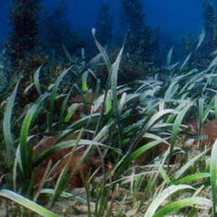
Strapweed (Posidonia australis). Photo: David Harasti
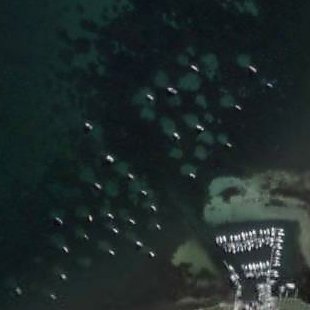
Aerial view of damage to seagrass caused by boat anchorage. Image: Google Earth
Fish Habitat Protection Plan 3 - Hawkesbury Nepean River System
Outlines management strategies and protection measures for aquatic habitats essential for the spawning, nursery, shelter and feeding requirements of fish in the Hawkesbury-Nepean River.
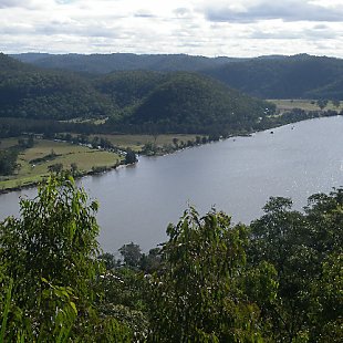
Hawkesbury River. Photo: Scott Machar
Workshops
Saving Aquatic Habitat in Stormwater Drains
Stormwater drains probably arent the first area that comes to mind when thinking about fish habitat, but fish, including the threatened Oxylean pygmy perch, live and breed in them. How these drains are constructed and maintained can have an impact on the potential for fish to survive and thrive. In November 2009, Industry and Investment NSW ran a successful, practical workshop for anyone with an interest in managing stormwater in rural areas. It included how-to sessions on on-ground works and the planning process and field visits, at which participants benefited from the experiences of staff from Richmond Valley Council. The workshop was supported by the NSW Government through its Environmental Trust.
A series of four factsheets was developed to complement the workshop:
- Assessing the habitat values of stormwater drains in coastal areas
- Managing coastal stormwater drains for aquatic habitat
- Retrofitting drains using Water Sensitive Urban Design principles
- Preparing a stormwater drain management plan in coastal areas
More information
Contact the Aquatic Habitat Protection Unit
