

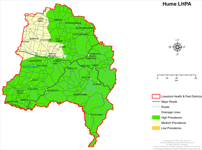
Hume LHPA - OJD Prevalence Areas
View large version of map (1.2Mb PDF)
High Prevalence Area (HPA)
All of the Hume LHP District except that part defined below as medium prevalence.
Medium Prevalence Area (MPA)
That part of the Hume LHP District generally north of the line commencing where the Lockhart- Collingullie Road transects the boundary of the Riverina LHPA and Hume LHPA following the Lockhart-Collingullie Road to the intersection with the Sturt Highway at Collingullie and then to the south of the Sturt Highway then heading generally west to the intersection with the Collingullie – Currawarna Rd.
Then that land to the west of the Collingullie-Currawarna Road heading generally north to the intersection with the Murrumbidgee River. Then that land to the north of line running east formed by the Murrumbidgee River until the river reaches meets the southern prolongation of the eastern boundary of portion 14 (DP751430/Lot 14), Parish of Wantabadgery, County of Clarendon.
Then all the land generally to the west of the following line from the Murrumbidgee River to the Great Southern Railway. From the intersection of the Murrumbidgee River and the southern prolongation of the eastern boundary of portion 14 (DP751430/Lot 14), Parish of Wantabadgery, County of Clarendon; by that prolongation and boundary northerly, the northern boundary of that portion westerly, part of the eastern, the northern and part of the western boundaries of portion 12 northerly, westerly and southerly, the northern and western boundaries of portion 15 and the western boundary of portion 6 westerly and southerly, the southern boundaries of portions 7 and 8 westerly, part of the eastern and part of the southern boundaries of portion 54 (DP751397/Lot 54), Parish of Bilda generally southerly and westerly, the southeastern boundary of portion 120 (DP751397/Lot 120) southwesterly, part of the eastern and southern boundaries of portion 171 (DP751397/Lot 171) generally westerly and southerly, and the southern and the western (and its prolongation) boundaries of portion 165 westerly and northerly to the road from Wantabadgery to Oura; by that road generally southwesterly to the southern prolongation of the generally western boundary of portion 179, by that prolongation and boundary generally northerly, the southern boundary of portion 15 westerly, part of the eastern and the southern boundaries of portion 24 and the southern boundary of portion 93 southerly and westerly, the western boundaries of the last-mentioned portion, a line, and portions 96, 97, 162, Parish of Claris, and part of the western boundary of portion 3 and the southern and western boundaries of portion 128 westerly and northerly, the generally western boundary of portion 151 generally northerly, the southern boundary and part of the western boundary of portion 154 generally westerly and northerly, part of the southern and the western boundaries of portion 117 westerly and northerly, part of the southern and the western boundaries of portion 178, Parish of Jeralgambeth, westerly and northerly, part of the southern boundary of portion 183 and its prolongation
westerly, part of the eastern boundary of portion 39 and the eastern and part of the northern boundaries of portion 130 northerly and westerly, the eastern boundaries of portions 131 and 134 and its prolongation northerly, the southern and western boundaries of portion 135 westerly and northerly, and the western boundary of portion 136 and its prolongation northerly, and the southern, the western and part of the northern boundaries of portion 166 westerly, northerly and easterly to the southern prolongation of the road forming the western boundaries of Lots 1 and 2 (DP599990), Parish of Wantiool, and portions 77, 79 and 78; by that prolongation and road northerly, the road forming the northern boundary of the last-mentioned portion easterly, Burnt Creek Lane generally northerly, the road from Junee to Eurongilly easterly, and the road forming the eastern boundaries of portions 116, 109 and 74 generally northerly, by the northern boundary of the last-mentioned portion and its prolongation westerly, part of the eastern and the northern boundaries of Lot 2 (DP188612), Parish of Boree, and the northern boundary of Lot 1 (DP188612) northerly and westerly, the western boundary of Lot 1 DP557593) and its prolongation northerly to the the intersection of that boundary line with the Great Southern Railway.
Then the land generally south of a line following the railway line (Great Southern Railway) to Junee then the branch line (South Western Railway) west to Marrar to the intersection with Marrar Road North.
Then the land generally to the west of a line commencing where the Junee–Marrar railway (South Western Railway) intersects with the Marrar North Road then generally north following the Marrar North Rd to the the Old Wagga South Rd, then on the Old Wagga South Rd to the Old Wagga Rd then on the Old Wagga Rd to the intersection with the Old Wagga North Rd then on the Old Wagga North Rd to Gaunts Rd then on Gaunts Rd to Smith’s Lane then on Smiths Lane to Speirs Lane then on Speirs Lane to the Mandama Rd until it meets the border with the Lachlan LHPA.
