
NSW State Seasonal Update - May 2018
Prepared by NSW DPI Climate Unit
NSW is experiencing widespread agronomic drought conditions. Available pasture and crop information shows that the production base of the state is under considerable stress. The widespread nature and intensity of the agronomic drought over Autumn has put livestock feed supplies under considerable strain.
NSW is experiencing widespread agronomic drought conditions. Available pasture and crop information shows that the production base of the state is under considerable stress. The widespread nature and intensity of the agronomic drought over Autumn has put livestock feed supplies under considerable strain.
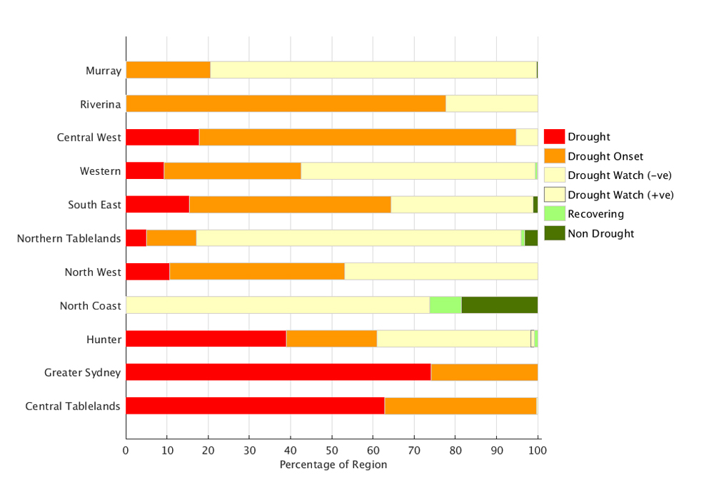
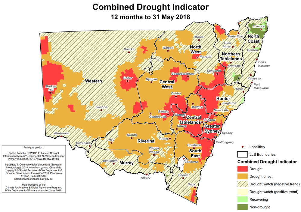
As of 31 May, approximately 99% of the State is covered by one of the three drought categories, with 39% of the state in Drought Watch, 44% in Drought Onset and 16% in Drought. It’s important to note that with agronomic drought indices at such low values, there will be minimal difference in on-ground and observable conditions (eg. feed availability) between Drought Onset and Drought categories. Seasonal conditions reported in April have further deteriorated and the vast majority of the agricultural production zone is in mild to severe drought.
The key driver of these conditions continues to be a wide spread soil moisture deficit and below average rainfall, resulting in very low agronomic indicators. The key agronomic indicator describing pasture and crop growth is extremely low, indicative of a failed autumn season in 2018 affecting large areas of NSW. This is evident in marginal on-ground conditions, such as minimal pasture availability and low ground cover. DPI has received numerous field reports describing feed deficits and limited sowing opportunities right across the state.
Isolated areas in the North Coast Local Land Services region continue to be in the Non-Drought category due to average rainfall.
The Combined Drought Indicator (CDI) establishes that a number of regions are currently in the most severe category of Drought. This includes parts of Hunter, Greater Sydney, Central Tablelands, Central West, North West, Northern Tablelands, Western and South East Local Land Services regions. This mean that these regions are experiencing more acute rainfall deficit, although it is important to recognise that poor agronomic conditions are being experienced across a much wider area of the state.
The area of Drought Onset is expanding rapidly, reflecting near historically low soil moisture, with the majority of areas currently in Drought Watch being very close to the thresholds for Drought Onset. This has seen the areas of NSW in the Drought Onset category continue to expand, and it is rapidly deteriorating. Currently this includes large parts of Western, Central Tablelands, North West, Northern Tablelands, North Coast, Hunter, Central West, Riverina, Murray, South East and parts of Greater Sydney.
The dry and warm conditions experienced in April extended well into May. A cold front passed through the state in mid-May, but it yielded minimal rainfall, and has done little to alleviate the widespread drought that has formed across the state.
The Bureau of Meteorology’s most recent official forecast has changed from April and now provides guidance that dry warm climatic conditions have a strong probability of continuing over the coming three months.
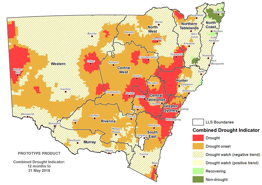
It is important to recognise the CDI provides an aggregated view of the State, and that on-ground conditions can be different to those displayed in the maps. They provide an ‘on average’ view of a particular region only.
Rainfall
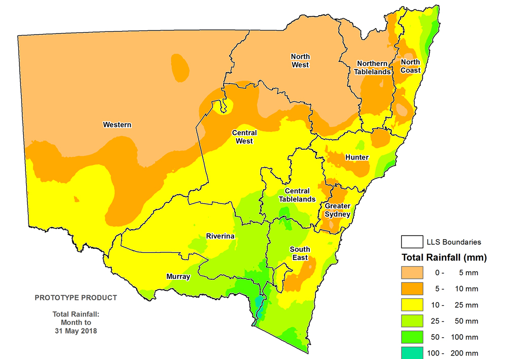
Rainfall totals were average to well below average across NSW. It was a very dry month in the north of NSW, with zero rainfall recorded at many stations. Elsewhere rainfall ranged from 0 to 25mm. Some heavier falls up to 50mm were recorded in parts of the eastern Riverina and Murray LLS regions, north-west and southern parts of South East LLS region, eastern areas of Hunter and the far north east of the North Coast LLS region (Figure 2). Isolated falls above 100mm were recorded in the alpine region. Large areas of Western, North West, Northern Tablelands, North Coast, Central West and Greater Sydney LLS regions received rainfall of less than 10mm.
Normalised Difference Vegetation Index (NDVI) Anomaly
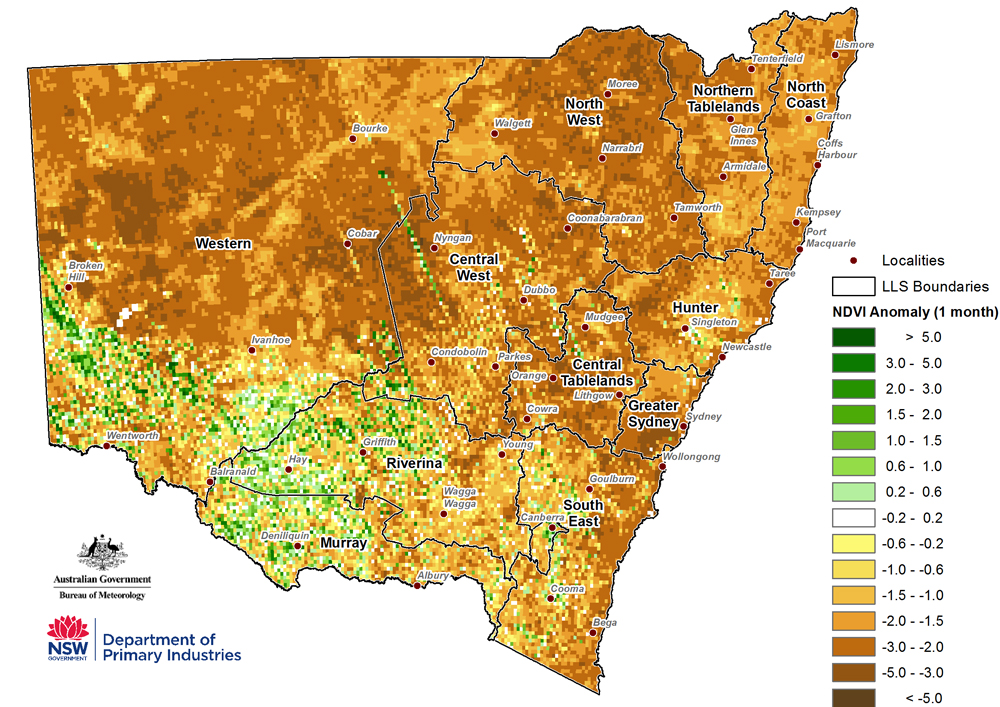
The monthly NDVI anomaly (Figure 3) data has problems related to satellite drift and the data for southern NSW requires careful interpretation. The available reliable data for central and northern NSW reinforces that crops and pastures are under significant stress and that this is widespread across much of the state.
Temperature
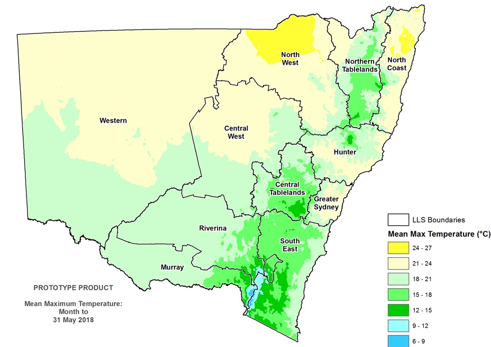
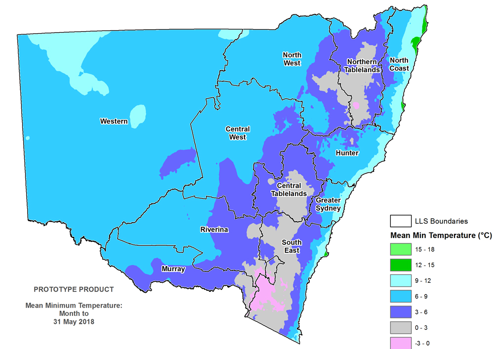
Most of inland NSW had mild to warm daytime temperatures of between 18-27°C (Figure 4), whilst in eastern NSW, temperatures ranges from 6-27ºC. Average overnight temperatures ranged between 3-12°C across most of NSW (Figure 5). Parts of the Northern Tablelands, Central Tablelands, South East LLS regions, and eastern parts of Riverina and Murray recorded average overnight temperatures of between 0-3°C, with parts of the alpine areas recording average overnight temperatures of between -3 to 0°C.
Extreme events
Light to heavy snowfalls were recorded in the Central Tablelands and alpine regions above 900m on the 10-11 May with the Bureau of Meteorology and other authorities issuing grazing and other livestock alerts. These events pose greater risks to livestock as pasture and stock condition deteriorate.
Rainfall Index
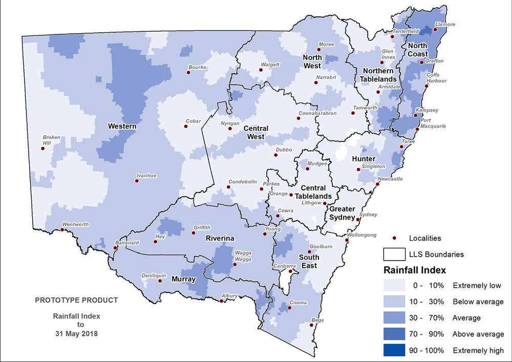
The Rainfall Index (RI, Figure 6) shows below average to extremely low rainfall across the majority of NSW. The North Coast LLS region has generally had average rainfall, although parts of this region are below average. Average rainfall is also evident in parts of Riverina, South East and Murray LLS regions.
There is a large band of average rainfall in Western LLS region, approximately 100-200km west of Cobar. Detailed inspection of the rainfall network in this region highlights that there are few active recording stations. This is compromising the accuracy of mapped rainfall and DPI is seeking further detailed field information. This has been confirmed by producer feedback on the daily drought mapping service.
Soil Water Index
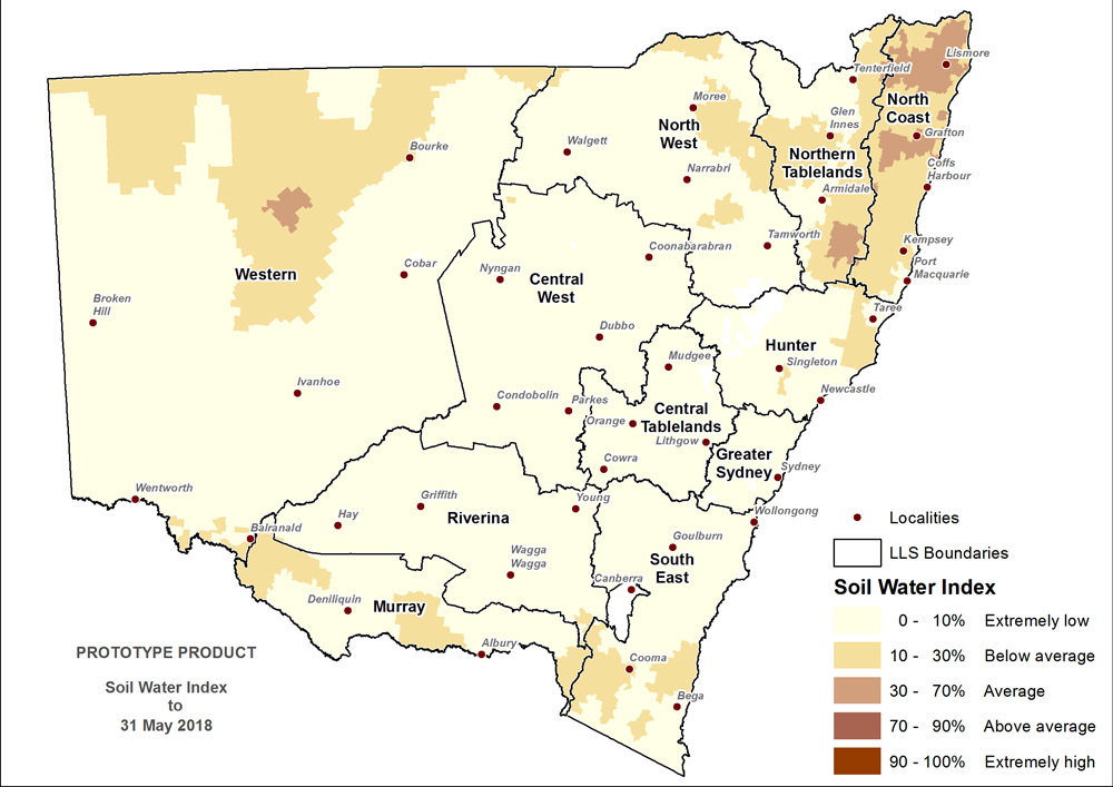
The Soil Water Index (SWI, Figure 7) shows that stored soil moisture is below average to extremely low across the majority of NSW. Isolated areas in North Coast and Northern Tablelands Local Land Services regions have average soil moisture levels. Soil moisture levels are extremely low across most of the cereal growing belt, the exception being isolated areas in Murray and North West LLS regions which are below average.
Plant Growth Index
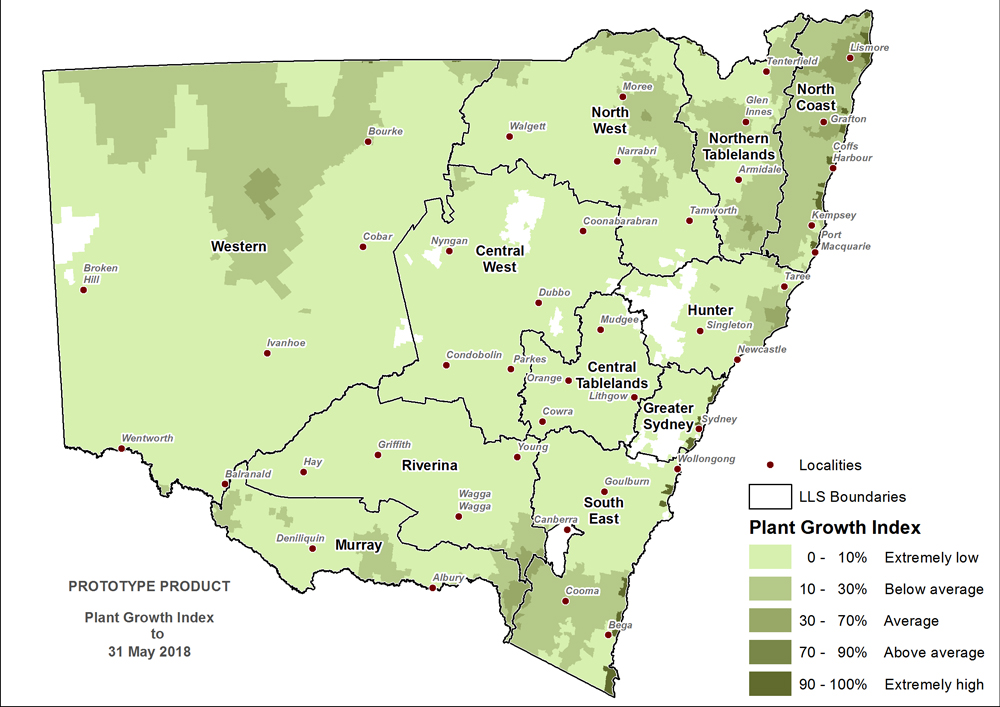
The Plant Growth Index (PGI, Figure 8) is below average to extremely low across the majority of NSW. Isolated areas in North Coast and far eastern Murray and Riverina Local Land Services regions have average plant growth levels. There are very small pockets of average plant growth along parts of the coast in the South East and North Coast LLS regions, which has been identified as errors in the PGI, and corrected in the verified drought maps.
Drought Direction Index
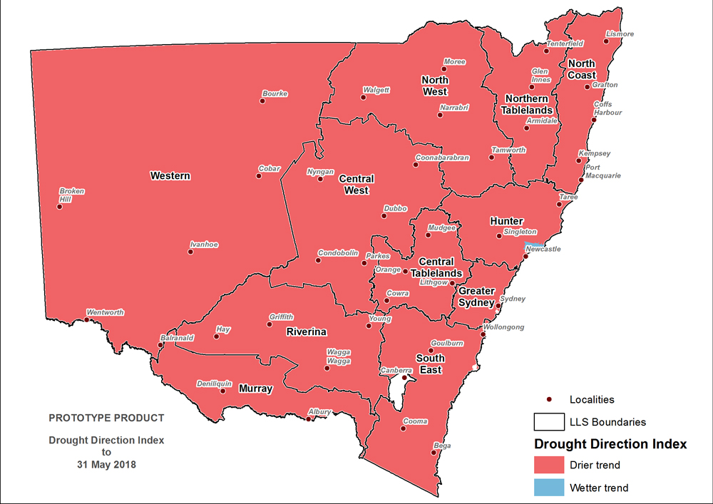
The Drought Direction Index (DDI, Figure 9) to 31 May shows a strong drying trend across NSW. The DDI reinforces that the State is in a widespread drying event consistent with entry and intensification of a drought event.
Changes in the individual drought indicators may have occurred since this update was released. For the most current information, please visit DroughtHub.
CDI status for the regions
Figure 10 displays the CDI status for each individual Local Land Services region to 31 May 2018.
Murray and Riverina regions
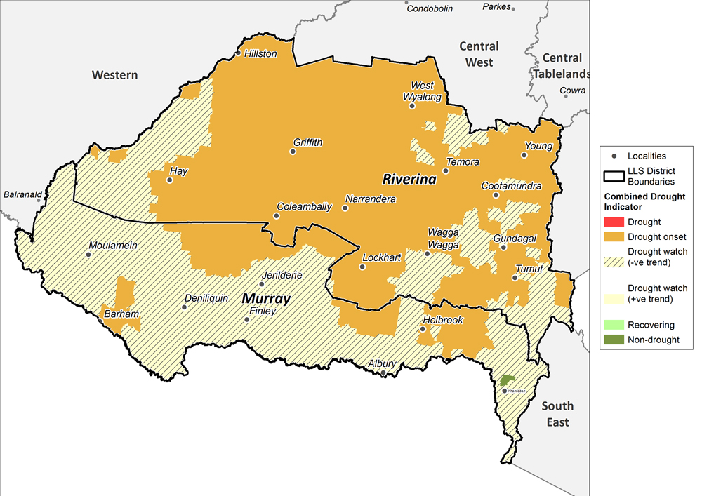
Conditions have and continue to deteriorate rapidly across the Murray and Riverina Local Land Services regions. The Combined Drought Indicator (to 31 May 2018; Figure 11) indicates that the entire region is experiencing drought conditions, with the majority of Riverina in the Drought Onset category, which extends into the Murray LLS region. Elsewhere the region is in the Drought Watch category but the indicator values are very close to triggering Drought Onset.
This has been driven by poor soil moisture and pasture/plant growth conditions, with soil water and plant growth indicators at historical lows. Parts of the area have received some rainfall, with Rainfall Index values in the below average (20-30%) range, so not at critical levels when considering historical rainfall variability. This reinforces the importance of considering rainfall effectiveness, and that current field conditions are best recognised as a severe agronomic drought.
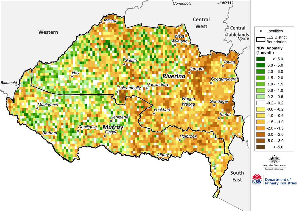
Where quality NDVI data is available (Figure 12), the low levels of greenness are indicative of highly stressed pastures across much of this region.
Western region
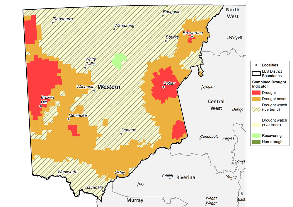
Conditions have continued to deteriorate across the Western Local Land Services region. The Combined Drought Indicator (to 31 May 2018; Figure 13) establishes that the entire region is experiencing drought conditions. A large part of the region transitioned from Drought Watch to Drought Onset between April and May. Similarly, the area experiencing highly intense drought (all indices at historical lows, i.e. the Drought category) expanded this month.
Close inspection of the agronomic indicators shows that the area currently classed as Drought Watch is very close to Drought Onset. In-field conditions, such as on ground biomass and ground cover, would appear very similar between these two categories. This is confirmed by both on-ground assessments from producers that have been made available to DPI this month as well as cross referencing the assessment made here to those available from the NSW Dust Watch.
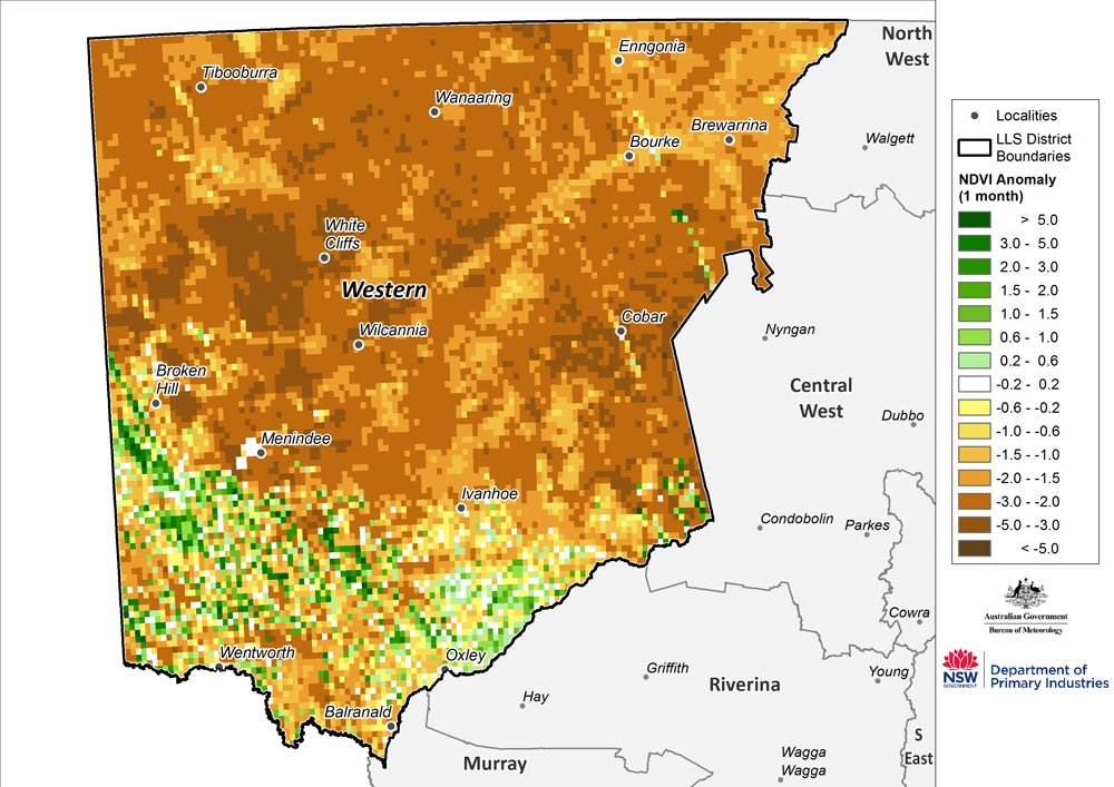
Where quality NDVI data is available (Figure 14), the low levels of greenness are indicative of highly stressed pasture and shrubs across much of this large district.
The NDVI data for the region approximately 200 km west of Cobar highlights that plant conditions in this zone are not different to the wider region. However, the drought indices and drought maps suggest that this area is experiencing better conditions than those reported for the wider Western LLS region. DPI has assessed the coverage of meteorological stations, soil types and available data tracking ground cover for this zone and advises that producers in this area are best considered to be in Drought Watch or Drought Onset. This is reflected in the verified drought map for the month (Figure 1). DPI is also seeking field reports to verify this assessment.
North West, Northern Tablelands and North Coast regions
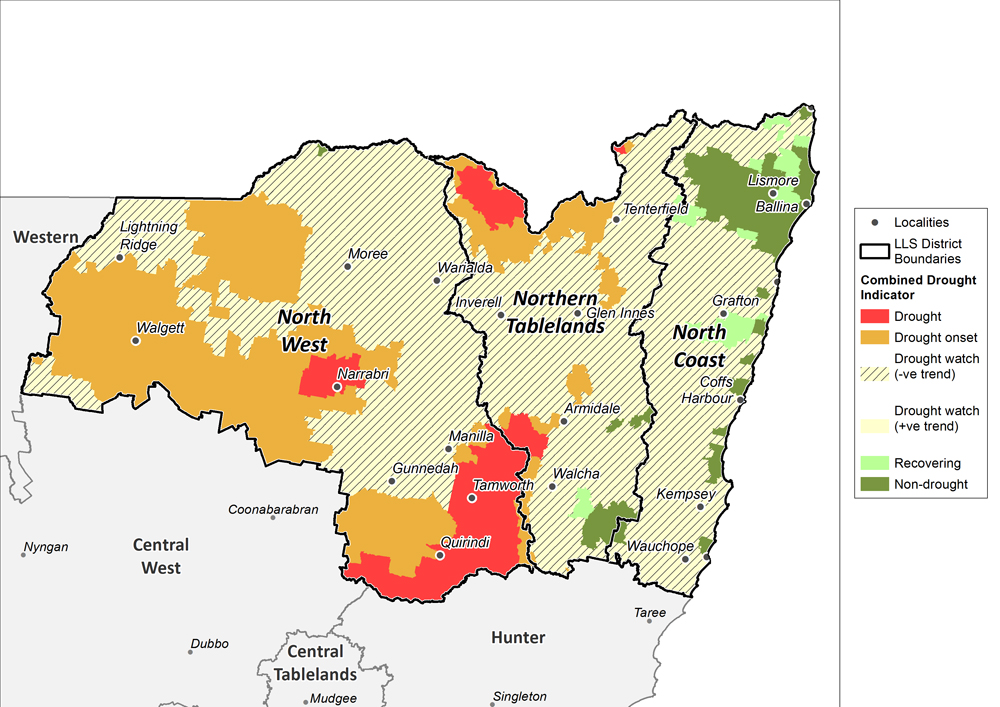
The North West and Northern Tablelands are in an agronomic drought. While the Rainfall Index varies across the region and some areas are only in below average meteorological conditions, the agronomic indices are at or very near to historical lows. This has seen the area of Drought Onset expand significantly during May and it continues to deteriorate on a daily basis. It is important to recognise that when the agronomic drought indices (SWI and PGI) are at these values there will be minimal difference in on-ground and observable conditions, for example feed availability.
Large parts of the North West and Northern Tablelands LLS regions still remain in the less intense Drought Watch category. However closer inspection of the index values shows that these are very close and rapidly approaching the values that trigger Drought Onset or Drought. It is important to recognise that producers in the Drought Watch area are undergoing similar climatic stress when compared to producers in Drought Onset (i.e. deteriorating agronomic drought). This is consistent with field reports and producer feedback that has been made available to DPI over the past month.
The North Coast LLS region has experienced wetter conditions when compared to the North West and Northern Tablelands, particularly to the north of this district. However there has been limited falls of rain over the last month in the south and western parts of the region, and these areas have now entered Drought Watch.
The coastal parishes on the North Coast that appear to be experiencing better conditions (Figure 15) are placed in Drought Watch in the verified map in Figure 1. Without detailed local field confirmation that better growth conditions are occurring on the coastal fringe, it is best to consider drought status in the region uniformly.
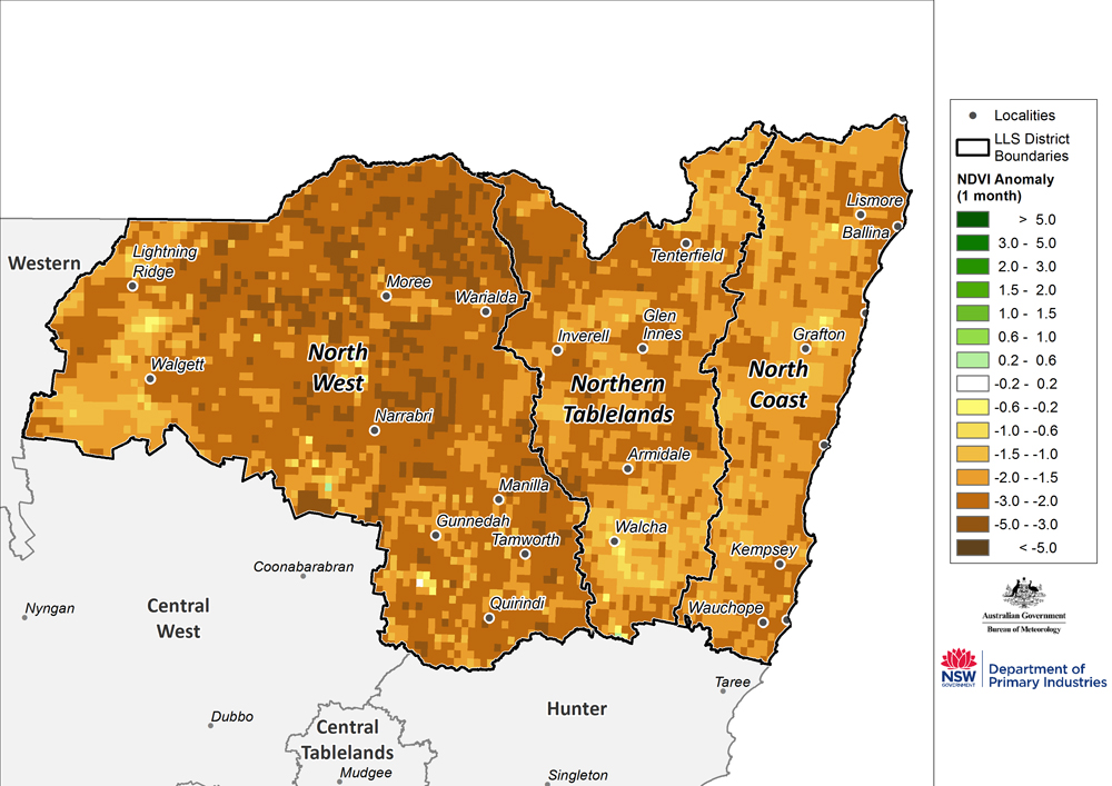
The monthly NDVI anomaly (Figure 16) indicates a decline in greenness across the region in the past month. The low levels of greenness are indicative of highly stress pasture and shrubs across the region.
Central Tablelands, Central West, Hunter and Greater Sydney regions
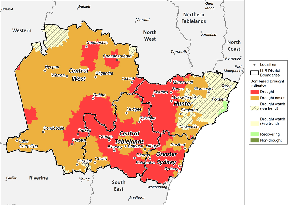
Conditions have and continue to deteriorate across the Central Tablelands, Central West, Hunter and Greater Sydney Local Land Services regions. The entire region is considered to be in a widespread and intensifying agronomic drought. The Combined Drought Indicator (to 31 May 2018; Figure 17) places the majority of the region in the Drought Onset or Drought categories.
There has been a slight improvement in conditions in the central and eastern parts of Hunter LLS region, however this region is still considered to be experiencing drought conditions, and parts are expected to transition back into the Drought Onset category. DPI continues to monitor the situation but there is significant likelihood that this part of the Hunter LLS might experience a false drought recovery.
The areas experiencing highly intense drought (all indices at historical lows, i.e. the Drought category) expanded this month, along with an area to the south of Coonamble transitioning into the Drought category.
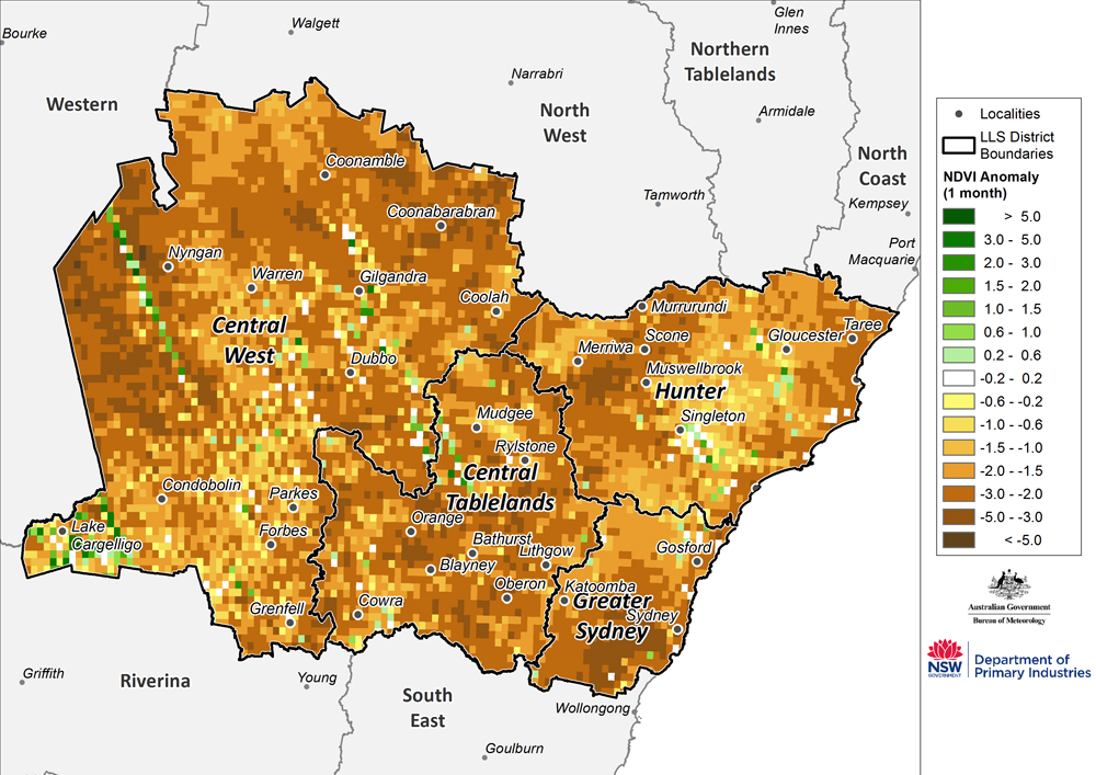
It is important to recognise that the agronomic indicators are at near historic lows across much of these LLS regions. In particular the Plant Growth Index has deteriorated during April and into May, and DPI would expect that acute livestock feed deficits would be associated with index values at this level. This has been confirmed by a large number of field reports from producers, LLS and DPI regional staff, which were made available over the course of the month.
Where quality NDVI anomaly data is available (Figure 18), the low levels of greenness are indicative of highly stressed pasture and shrubs across the region.
South East region
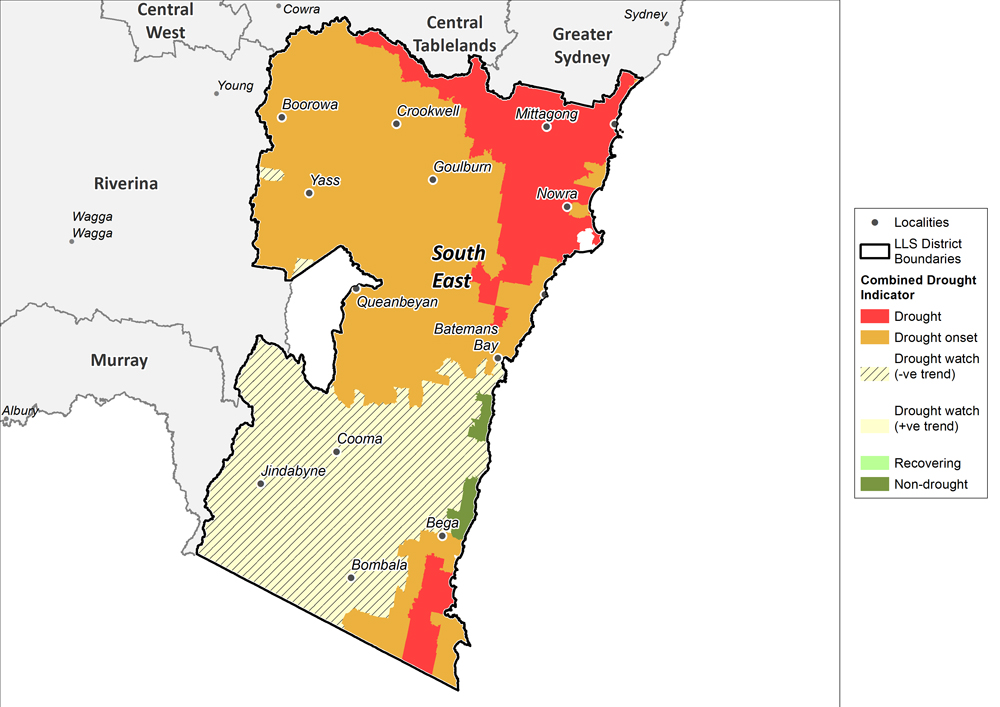
Conditions have and continued to deteriorate across the South East Local Land Services region. The Combined Drought Indicator (to 31 May 2018; Figure 19) establishes that the majority of the region is experiencing drought conditions. The extent of Drought in the north of the region has increased and a new area in the far south east has transitioned into Drought, the most severe of the three drought categories.
Elsewhere the region is in the Drought Watch or Drought Onset categories. This has been driven by low soil moisture and pasture/plant growth conditions. Isolated parts around Bega and south of Bateman’s Bay appear to be in the Non-Drought, however close inspection of the agronomic indicators shows that this is a data error due to inaccuracies in the evaporation field on the coast. As a result DPI has corrected the historical dataset and adjusted the verified monthly drought map and places these areas in Drought Watch.
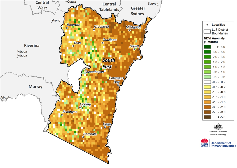
Where quality NDVI anomaly data is available (Figure 20), the low levels of greenness are indicative of highly stressed pastures across the region.
Official national outlook
The official national climate outlook for June to August was issued by the Bureau of Meteorology on 31 May 2018. The outlook has significantly changed from that issued in April with dry conditions now more likely to occur over the next three months. The latest outlook shows that the southeast mainland of Australia, southern Queensland, the majority of South Australia and parts of Western Australia are likely to be drier than average over the next three months. Parts of eastern Tasmania are likely to be wetter than average. Elsewhere, there are near-equal chances of a wetter or drier than average three months.
June to August daytime temperatures have an increased likelihood of being warmer than average across most of Australia, except for parts of the far north. Overnight temperatures have an increased likelihood of being warmer than average for the majority of Australia, except for parts of the far north.
NSW outlook
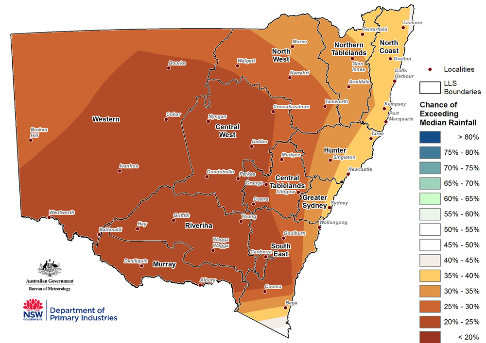
For New South Wales, the rainfall outlook (Figure 21) for June to August indicates that there is an increased chance of drier than normal conditions across the majority of NSW. The bulk of the state now has between a 20 to 35% chance of exceeding median rainfall.
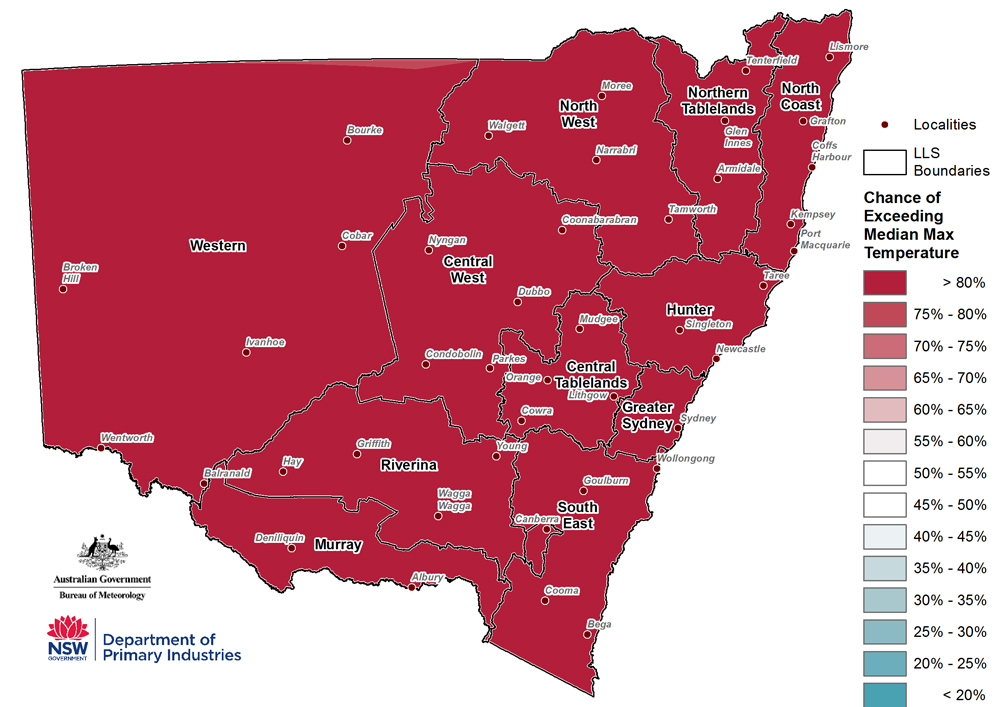
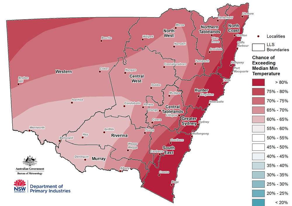
The temperature outlook (Figure 22 & Figure 23) indicates that there is an 80% chance of warmer than normal daytime temperatures across NSW. Overnight temperatures also have an increased likelihood of being warmer than normal across NSW.
Importantly this forecast is based on the Bureau of Meteorology dynamic climate model output and heavily weights synoptic settings influencing Australia. Typically global teleconnections (ENSO and IPO) have a stronger weighting in the forecast but these are currently in a neutral state which is forecast to continue.
Overall, global climate models favour a near-neutral outlook for rainfall for NSW during June to August (Table 1). The temperature outlook tends to favours near-neutral conditions, with two models showing general cooler conditions and three showing generally warmer conditions. However these are based largely on the settings of global teleconnections rather than the local synoptic drivers that have influenced the Bureau of Meteorology official forecasts this month.
Model Ensemble
Table 1: Overall NSW outlook – number of major climate models in each general category (as at 1 June 2018)
Rainfall | Generally wetter | Generally near-neutral | Generally drier |
|---|---|---|---|
June - August | 0 | 13 | 0 |
Temperature | Generally warmer | Generally near-neutral | Generally cooler |
June - August | 3 | 8 | 2 |
Climate drivers
ENSO
Indicators for the El Niño Southern Oscillation (ENSO) remain neutral (as at 22 May 2018). Most climate models suggest a neutral outlook into winter, with little sign of El Niño or La Niña developing in the coming months.
Southern Oscillation Index and other indicators
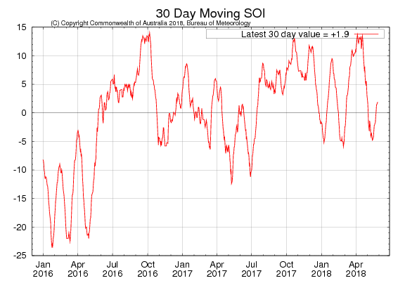
The 30-day SOI value (Figure 24) is currently within the neutral range (30-day value was +1.9 as at 30 May). Fluctuations in the SOI usually decrease over the winter as the tropical monsoon system breaks down.
Cloud levels at the junction of the equator and the International Date Line have been below average since late February. Trade winds (as at 22 May) are near average across most of the central Pacific.
Sea surface temperatures
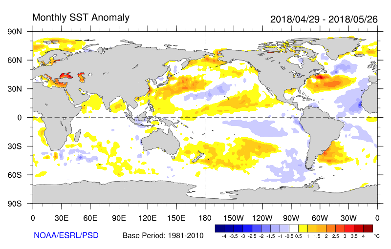
Monthly sea surface temperatures anomalies (SST, Figure 25) remain cool across the central and eastern equatorial Pacific, although the area of cool water has weakened over the past month, and remains with the Bureau of Meteorology’s neutral range (between -0.8 and +0.8) in the NINO3 and NINO3.4 regions. A large area of warmer than average water is present across the South Pacific region, extending from the south eastern Australian coastline through to the central Pacific.
Sea Sub-surface Temperatures
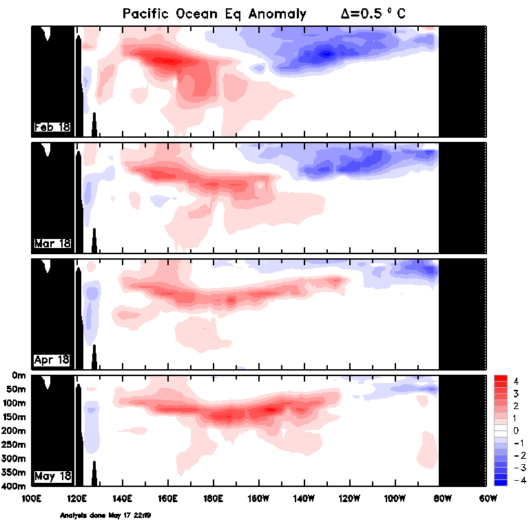
A warm sub-surface anomaly developed in the western equatorial during February, and has moved eastwards over the past few months into the eastern-central Pacific (Figure 26). The passage of the warm anomaly eastwards has greatly decreased the extent of the cool anomaly in the central and eastern Pacific.
Indian Ocean
The Indian Ocean Dipole (IOD) is currently neutral (as at 20 May 2018). Indications from climate models show no clear indication of a negative or positive IOD during winter.
Southern Ocean
Forecasts of the Southern Annular Mode (SAM) are varied for this month with approximately half the model ensemble indicating strengthening and the other half indicating a weakening of the mode. This is not an unusual feature of SAM which has high variability and can have limited forecast skill.
How does it work?
Much of the information in the Seasonal Conditions Report is sourced from the NSW DPI Enhanced Drought Information System (EDIS) ™. The EDIS system is currently available in prototype form and is subject to an intensive ground truthing process. For more information, visit the interactive website via DroughtHub.
EDIS is an ongoing project aimed at improving the quality and timeliness of efforts to monitor conditions across the state. Key features of the system are:
- It tracks drought by using four indicators; rainfall, soil moisture, plant growth, as well as tracing rainfall trends. Agronomic conditions have equal value to rainfall recorded at meteorological stations.
- The Combined Drought Indicator (CDI) brings this information together, and has been designed to characterise developing drought conditions. The key purpose for building the CDI was as a drought early warning system.
- The rainfall, soil moisture and plant growth indicators in EDIS account for conditions over a 12 month window. This provides a compromise between a highly sensitive indicator (e.g. six months) and a less sensitive indicator (e.g. 24 months).
- Climate and remote sensing data drive the information system at a high resolution, but the CDI is reported at a Parish level.
- Because of its configuration and purpose, there will be differences to the indicator used in the National Drought Monitoring Framework (the Australian Rainfall Deficiency Analyser) which relies on rainfall alone.
- The CDI has three drought categories that characterise NSW according to drought intensity as well as the main drivers of a drought event (meteorological, hydrological and agronomic). DPI considers areas in Drought Watch to be experiencing a drought event.
- The Drought Watch category encompasses a wide range of conditions from the very early stages of drought entry through to a drought event becoming intense. This enables the drought monitoring system to detect a drought event early. It is also possible to stay in the Drought Watch category for some period of time.
More services from EDIS are scheduled for release over the coming months including a seasonal conditions self-reporting application.
The way in which the indicators are combined to form the CDI is described in Table 2 below.
Table 2: Description of the Combined Drought Indicator framework
CDI Phase | Technical definition | Description - typical field conditions |
|---|---|---|
Drought | All three indicators (rainfall, soil water, plant growth) are below the 5th percentile | Ground cover is very low, soil moisture stores are exhausted and rainfall has been minimal over the past 6-12 months. |
Drought Onset | At least one indicator is below the 5th percentile | Conditions may be very dry, or agronomic production is tight (low soil moisture or plant growth). It is possible to be in drought onset when there has been some modest growth, or a few falls of rain. |
Drought Watch (negative trend) | At least one indicator is below the 30th percentile and the rainfall trend is negative over the past 90 days. | Conditions are deteriorating; production is beginning to get tighter. Ground cover may be modest, but growth is moderate to low for the time of year. When indicators are close to the Drought Onset threshold drought conditions are severe. |
Drought Watch (positive trend) | At least one indicator is below the 30th percentile and the rainfall trend is positive over the past 90 days. | Production conditions are getting tighter, but there have been some falls of rain over the past month. It is rare to enter the Recovering phase from the Non-Drought category; Usually there is a quick (1-2 week) transition into Drought Watch or Drought Onset. When indicators are close to the Drought Onset threshold drought conditions are severe. |
Recovering | All indicators are below the 50th percentile but above the 30th percentile | Production is occurring but would be considered ‘below average’. Full production recovery may not have occurred if this area has experienced drought conditions over the past six months. |
Non-drought | At least one indicator is above the 50th percentile. | Production is not limited by climatic conditions. |
The NSW State Seasonal Update is provided each month by the NSW DPI Climate Unit, which is part of the Livestock Systems Branch in DPI Agriculture.
Information used in this report was primarily sourced from the Australian Bureau of Meteorology, the US National Oceanic and Atmospheric Administration, the International Research Institute for Climate and Society (Columbia University) and NSW Department of Primary Industries.
Maps in this document contain data which is © Spatial Services – NSW Department of Finance, Services and Innovation (2018), Panorama Avenue, Bathurst 2795 and data which is © Commonwealth of Australia 2018, Australian Bureau of Meteorology, Melbourne. All rights reserved.
The seasonal outlooks presented in this report are obtained from the Australian Bureau of Meteorology and other sources (including World Meteorological Organisation Global Producing Centres). These outlooks are general statements about the likelihood (chance) of (for example) exceeding the median rainfall or minimum or maximum temperatures. Such probability outlooks should not be used as categorical or definitive forecasts, but should be regarded as tools to assist in risk management and decision making. Changes in seasonal outlooks may have occurred since this report was released. Outlook information was up to date as at 4 June 2018.
All climate and remote sensing input data is supplied to the Enhanced Drought Information System ™ under the Australian Creative Commons Licence (CCY 4.0) and is made available by the Terrestrial Ecosystem Research Network.
© State of New South Wales through the Department of Industry, Skills and Regional Development, 2018. You may copy, distribute and otherwise freely deal with this publication for any purpose, provided that you attribute the NSW Department of Primary Industries as the owner.
Disclaimer: The information contained in this publication is based on knowledge and understanding at the time of writing (June 2018). However, because of advances in knowledge, users are reminded of the need to ensure that information upon which they rely is up to date and to check currency of the information with the appropriate officer of the Department of Primary Industries or the user’s independent adviser.

