A NSW Government website

WA Eastern Regional Summary


The region

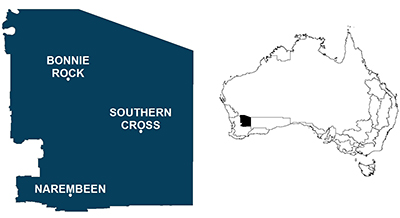
A map showing the locations covered by this region

The WA Eastern agroecological zone is centered around Merredin and extends to Mount Gibson in the north and Narembeen in the south. Rainfall in the zone averages around 400 mm annum-1 and rainfall seasonality is winter-dominant. Boundaries for the zone are shown in Figure 1.

Modelling regional practices

Producing models that reflect all farming practices throughout a region is difficult so “common practice” models for wheat and lupins for the region were produced. A wheat crop with a 1.0 t ha-1 yield and 13 kg of fertiliser N applied ha -1 and a lupins crop with a yield of 0.4 t ha-1 and 2 kg of fertiliser N ha -1 applied were modelled. The key assumptions of these models were that;

  • Only one pass was made at sowing
  • Split fertiliser applications were used for canola crops
  • It was assumed that wheat and lupins crops had two fallow sprays. Wheat and lupins had one in-crop herbicide and lupins also had one pesticide application.
  • Stubble was retained
  • Lime was applied at the equivalent rate of 4 t ha-1 every decade and incorporated through scarification

Impact indicators

Hydrogen ion impacts estimate the release of hydrogen ions to the soil associated with crop production. A negative value indicates a reduction in soil acidity whereas a positive value indicates an increase in soil acidity. Soil erosion is an estimate of soil loss that occurs during the production of the crop. The depth of soil lost will depend on many things but an approximate conversion is that 1.5 t of soil loss equals 1 mm of soil. Global warming impacts are the release of greenhouse gases to the atmosphere expressed as carbon dioxide equivalents (CO2-e), Eutrophication impacts are the release of phosphorous to the environment and are expressed as phosphate equivalents and Particulate Matter impacts are the release of fine particles less than 2.3 micrometres in diameter.

Benchmark results

Results below in Table 1 show the environmental impacts of producing a t of wheat or lupins in the region. Lime use in the region resulted in a reduction in free hydrogen ions in the soil for all crops and soil erosion was estimated at between 5.6 and 12.2 t soil loss t product-1. Analysis indicated that Global warming impacts associated with the production of these crops ranged from between 351 and 418 kg CO2-e, Eutrophication impacts ranged between 1.7 and 2.1 kg PO4-e and Particulate Matter impacts ranged between 0.45 and 0.46 kg of < 2.3 µm particulate matter t product-1.

Table 1: Hydrogen ion changes, soil erosion and Global Warming, Eutrophication and Particulate matter impacts associated with the production of wheat and lupins in the WA Eastern agroecological zone.

Hydrogen ions

Soil erosion

Global warming

Eutrophication

Particulate matter


(kg H+)

(t soil loss)

(kg CO2-e)

(kg PO4-e)

(kg PM2.3)

Wheat

-372.72

5.64

418.44

1.71

0.45

Lupins

-814.55

12.18

351.15

2.07

0.46


Greenhouse gas emissions

The emissions profile for wheat and lupins grown in the region are shown below in figure 2. For wheat, the greatest source of emissions was from the use of fertiliser and transport and lime production and use made the least greatest contribution to total emissions. Residue emissions made the greatest contribution to the total emissions of lupins production but fertiliser production and use, tractor operations and chemical production also made considerable contributions to total emissions.

Figure 2: Greenhouse gas emissions profile for the production of wheat and lupins in the WA Eastern agroecological zone.

Greenhouse gas mitigation strategies

Mitigation strategies tested for the region were;

  • Sustainable intensification
  • Additional applications of lime
  • Implementation of variable rate fertiliser technology
  • Changing a wheat-wheat rotation to a legume-wheat rotation

More information on the assumptions used to test these strategies and how they might reflect individual enterprises are available on the Mitigation strategies page.

Results (figure 3 below) indicate that emissions of a t of wheat can be reduced by;

  • 42% through the implementation of sustainable intensification
  • 33% by additional lime applications
  • 12% by implementation of variable rate fertiliser technology

Results also indicate the replacing a wheat crop with a legume crop in a two-crop rotation can increase greenhouse gas emissions intensity by 118%.

Figure 3: Reductions in greenhouse gas emissions for wheat production when grown with sustainable intensification, variable fertiliser, additional lime applications and legume - wheat mitigation strategies in the WA Eastern agroecological zone.


Accessible Content

Accessible versions of the raw data used to generate these charts is below.


Greenhouse Gas Emissions Profile

Wheat

Canola

Lupins

Lime production

10.61789

9.087379

5.09444

Lime use

18.0076

15.41191

8.640008

Fertiliser production

22.60139

196.0927

53.20593

Fertiliser use

N/A

242.7563

19.44493

Residue emissions

54.9992

116.0882

78.67765

Transport

10.02208

9.92871

4.84326

Tractor operations

186.1504

59.79484

61.54978

Chemical production

45.5608

64.1995

59.37448

Calc total

N/A

688.8602

277.096

Mitigation Stategies

StrategyResult

Sustainable intensification

-42

Legume wheat rotation

118

Additional lime applications

-12

Variable rate technology fertiliser

-33