
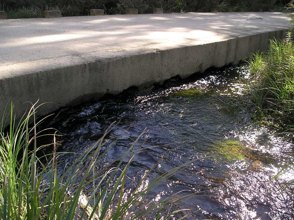
Manyweathers Weir removal
Manyweathers Weir was one of 4 weirs constructed across the Richmond River around the township of Casino in northern NSW. Named after Mr Richmond Manyweathers MBE who was Casino’s longest serving Mayor and a Member of State Parliament, the weir was originally built to provide a secure water supply for the town of Casino. However, in 1985 the weir became obsolete after the town's water supply was sourced from Jabour Weir (the next weir upstream). Despite no longer being required, the weir continued to hold local heritage significance and, due to an 800 mm height difference between upstream and downstream water levels, block fish passage at lower flows. As part of the Bringing Back the Fish Project, structure owners State Water (now WaterNSW) and project partners Richmond Valley Council, and the Recreational Fishing Trust, addressed environmental and heritage concerns, allowing the weir to be removed over a 10 day period in 2009.

Manyweathers Weir Removal - Richmond River
Weir formed a barrier even in elevated flows

Manyweathers Weir Removal - Richmond River
Weir was gradually broken into pieces for removal

Manyweathers Weir Removal - Richmond River
Weir nearing full removal

Manyweathers Weir Removal - Richmond River
Final stages of removal and water levels on either side of the structure equalising

Manyweathers Weir Removal - Richmond River
Weir removal allows for free fish passage within the Richmond River
Tomago floodgate improvement
Standard hinge-flap floodgates at Tomago limited tidal exchange to the 226 ha Tomago coastal wetlands and ring drain at Fullerton Cove in the Hunter River estuary. Wetland drainage associated with the floodgates resulted in the exposure of acid sulfate soils, scalded soils, and acidic waters entering the Hunter River. Intervention was required management to reduce these impacts.
A series of “Smartgates” were installed onto four of the Tomago floodgates to monitor water quality using sensors. In response to set water quality parameters, the sensors would manage how much tidal water could enter into the drain through an opening in the main hinge-flap gate, allowing for improved water exchange and management of the acidic water. The project was managed by the Department of Climate Change Energy, Environment and Water with funding and support from Hunter Local Land Services.
Recently additional improvements are being made at this site with newly designed swing gates further improving tidal flows from the Hunter River to the wetlands as part of the Marine Estate Management Strategy’s Coastal wetland rehabilitation project.
In total, improved management of 54 floodgates along the NSW coast was achieved as part of the Bringing Back the Fish Project, including Bayview autotidal floodgate within the Hawkesbury River catchment, shown in the banner image at the top of this page.

Tomago floodgates fitted with smart gates
(low tide)

Tomago floodgates fitted with smart gates
(high tide)
Turella Weir fishway
The Turella Weir is located on Wolli Creek in inner Sydney and marks the tidal limit of Wolli Creek where it separates the freshwater from the estuary. The original weir was built in the early 1900’s to provide access and water for the adjacent Chinese Market Gardens. In 2009, as part of the Bringing Back the Fish project, a partial width rock ramp fishway was constructed in partnership with Rockdale and Canterbury City Councils, and Greater Sydney Local Land Services.
This fishway was designed to operate at the top of the tidal cycle, is narrower than a standard design to fit the environment and the weir space available and comprises a series of ridges and pools that allow fish to move upstream past the weir and access 3 km of habitat.
The following video shows juvenile mullet making use of the fishway to access upstream habitat.

Turella Weir before
Wolli Creek

Turella Weir fishway
Fishway installed and operating near high tide

Turella Weir fishway
Looking downstream

Turella Weir fishway
Looking upstream

Monitoring of fish at Turella Weir
Fishway shown at low tide when fish passage is not possible
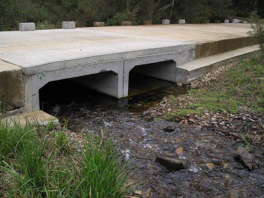
Northangera Road improvement
One of many road crossings addressed as part of the Bringing Back the Fish project, Northangera Road (locally known as Bourkes Crossing) crosses the Mongarlowe River in the upper Shoalhaven River catchment.
Three inadequately sized pipe culverts blocked upstream fish passage due to high water velocities. These pipe culverts were removed and replaced with larger box culverts to reduce flow velocities. One culvert was set at a level to ensure there was adequate water depth through the culvert to allow for fish passage at low flows. An adjacent culvert, and one on a secondary flow path were set slightly higher to ensure water velocities remained low, even at higher river flows. Works were completed in 2009 and improved access to 43 km of fish habitat, benefiting the threatened Macquarie Perch population present in Mongarlowe River.
Northangera Road inadequate pipes
Upstream side - high water velocities, low light and sedimentation blocked fish passage
Northangera Road box culverts
Upstream side - fish can now access habitat upstream of Northangera Road

Northangera Road inadequate pipes
Downstream side - small pipes were inadequate for flows in Mongarlowe River

Northangera Road box culverts
Downstream side - fish can now access and pass under Northangera Road