Inadequate or lack of culverts
completely block water and fish passage past the crossing
Elevated pipe and apron
Shallow water depth across the crossing surface and long apron blocks fish passage
Pipe culverts
Pipes convey water but can create high water velocities that block fish passage
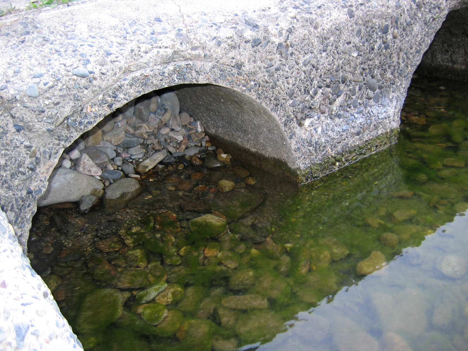
Sediment blockage
Gravel and sediment can collect in culverts blocking fish passage
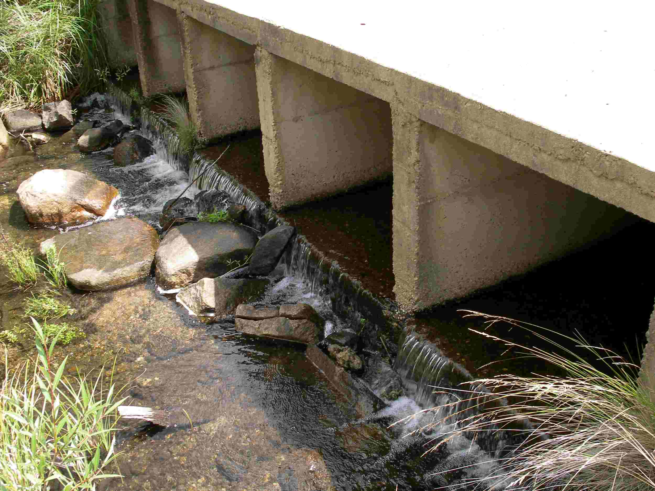
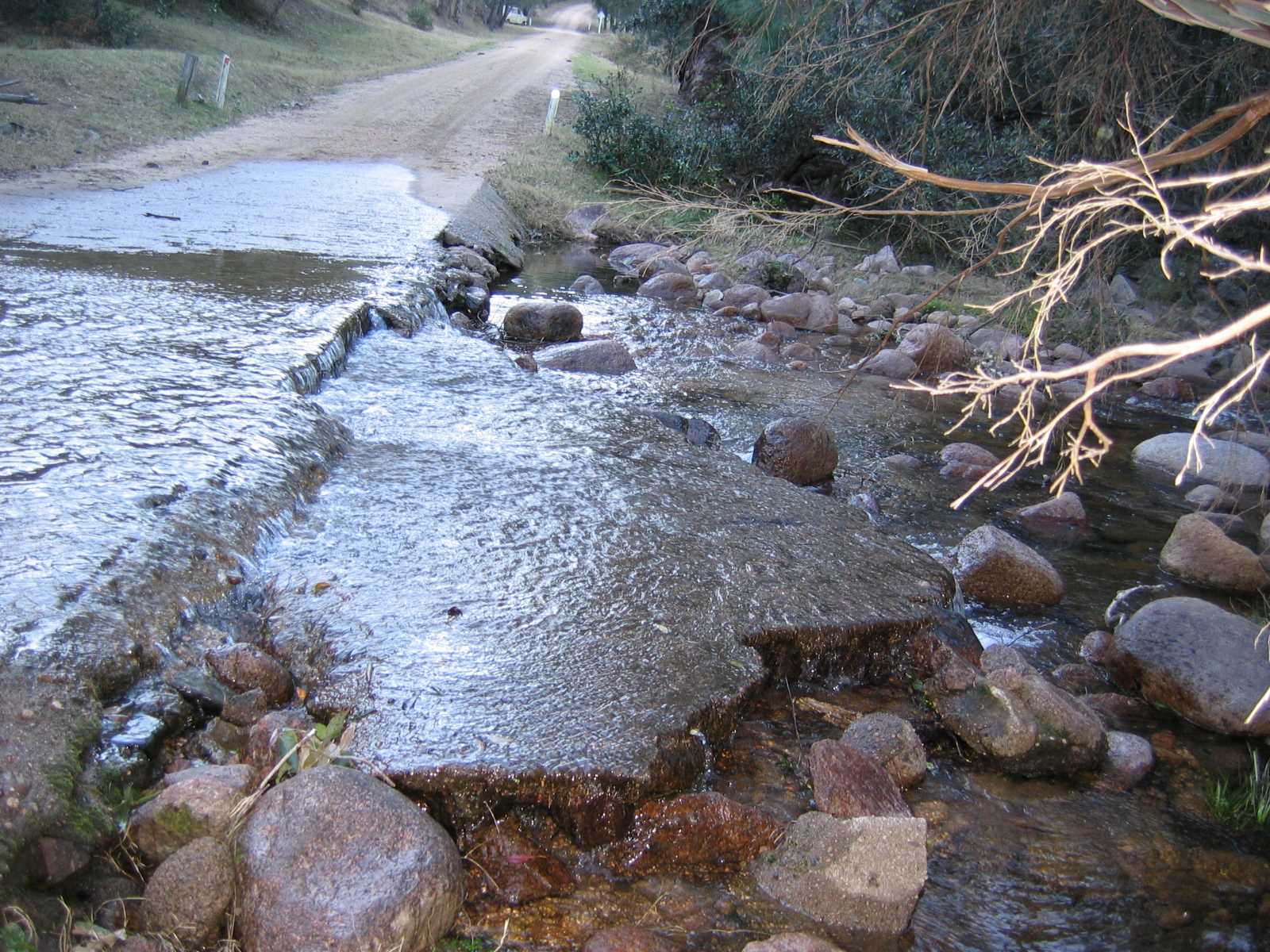
"Sheet flow" and drop off
prevent fish passage due to shallow "sheeting" water and a drop off on the downstream side creating a waterfall effect
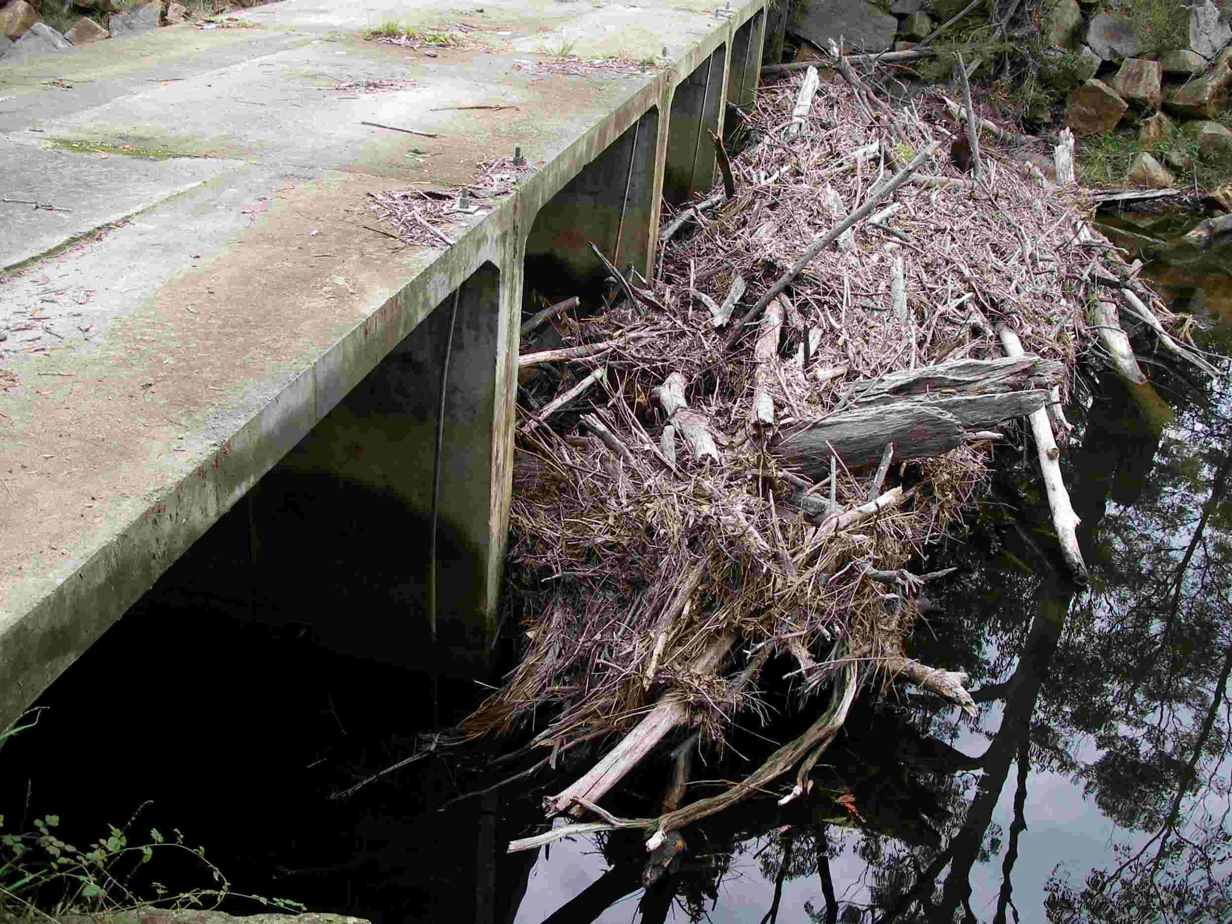
Debris blocking fish passage
poor maintenance and high flow events can result in blocking fish movement
Road crossings (or waterway crossings) such as causeways, culverts and even bridges can act as barriers to fish passage by creating a physical blockage, a hydrological barrier, or by forming artificial conditions that act as behavioural barriers to fish. This can occur as a result of poor design or as waterway conditions change over time. The impact of road crossings on fish passage will vary depending on:
- the design of the structure
- the nature of flow, debris and sediment movement in the waterway
- the swimming capabilities and behaviour of resident fish.
In general, bridges and arch structures promote natural, unimpeded stream flow, allowing the free movement of fish underneath the structure during a wide range of hydrological conditions.1 Other structures described below have issues with “drownout” (when water flows over the top and submerges a crossing, mainly during flooding flows) and “headloss” (the difference in water level either side of the structure; otherwise known as the waterfall effect). High water velocities and excessive headloss are particularly problematic for Australian native fish, which are known for their poor swimming performance compared to their northern hemisphere counterparts.2
Some crossings - causeways in particular - are also a public safety issue during elevated flows when water depth and velocity become difficult to determine and vehicles entering the waterway are washed off the road surface and further downstream.
In tidal reaches, waterway crossings (especially those over agricultural drains) commonly incorporate floodgates that restrict fish passage between flood events. Between floods, floodgates are generally maintained in the closed position thus ensuring a complete blockage to fish migration between estuaries and tidal tributaries. For more information see Floodgates.

Did you know ...
A fall of only 10cm is enough to create a barrier that will block fish passage.

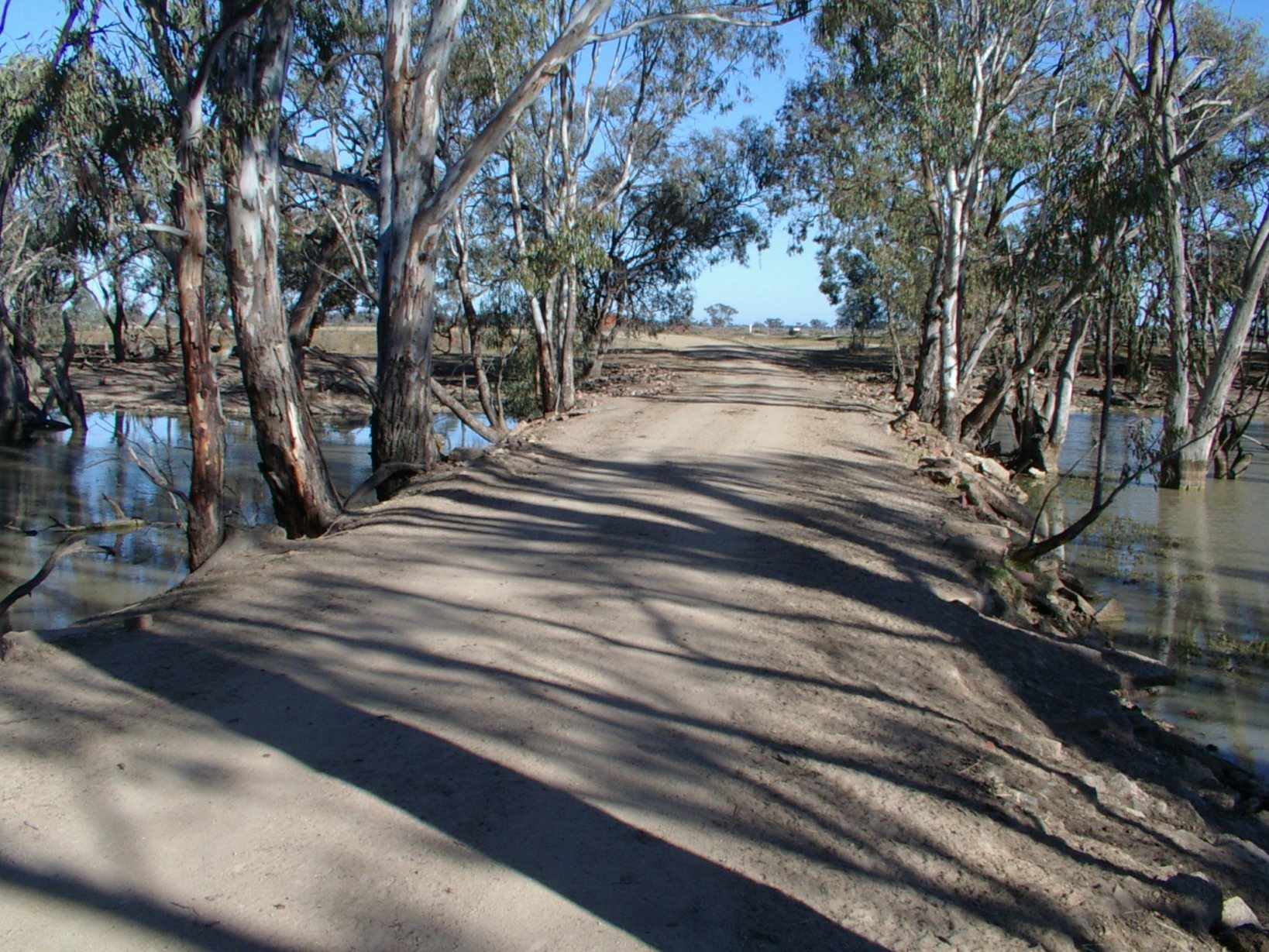
Causeways
Low-level crossings such as causeways are generally constructed near bed-level. They are designed to convey water across the road surface as sheet flow or under the road in small pipes or box culverts.
Causeways become submerged (drownout) relatively quickly, however shallow water depth (< 100 mm) over the road surface restricts fish passage for larger fish. Prior to drownout, a waterfall effect is often observed on the downstream side of the structure. This is caused by the height difference between upstream and downstream water levels (also known as headloss) and acts to block fish passage. Headloss can be a function of structure design, or it can form over time as water scours the downstream waterway bed.
Causeways are also a public safety issue, particularly during elevated flows when water depth and velocity become difficult to determine, leading to vehicles being washed off the road surface and into the waterway downstream.
In some cases, causeways have low-flow pipes beneath the roadway that can further restrict fish passage as outlined below for piped culverts.

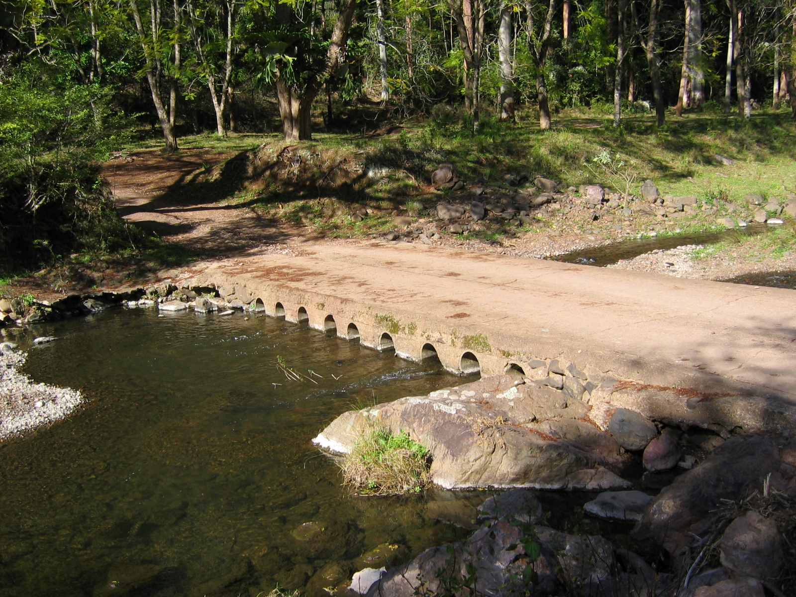
Pipe culverts
Waterway crossings employing round culverts (pipes) to pass water beneath the road surface are particularly problematic to native fish. The number and size of pipes installed can be inadequate for the flows within a waterway. This leads to water being constricted and pushed through narrow openings, increasing water velocities within the pipe.
Because of the smooth, uniform nature of a pipe, there is no opportunity for water to slow within a pipe. This means that once in the pipe, fish moving upstream must expend large amounts of energy to swim against the linear flow and are not able to rest until they emerge upstream. Depending on the swimming ability of the fish, this often makes traversing the crossing impossible and fish get washed back downstream.

Box culverts
Box culverts employ square or rectangular shaped culverts to pass water beneath the road surface. These culverts (also called cells) can be different sizes, but vary from pipe culverts by providing an area of lower velocity water in the corners of each cell. Fish can more easily move upstream through these culverts by sticking close to these lower water velocity areas.
Both pipe and box culverts can also act as a physical barrier to migrating fish where poor design or scouring of the downstream riverbed increases the headloss across the structure and making it difficult for fish to actually reach the structure itself until the crossing is drowned out during a flood.
For both causeways and culverts fish movement may also be restricted if they form a long, dark space that fish won't enter. Equally, debris building up at the cell opening can also physically block fish passage.

Ford Crossings
Fords are formed directly on the channel bed (i.e. “wet crossing”), which eliminates the waterfall effect observed on the downstream side of causeways. They should have minimal effect on fish passage due to their low vertical profile.
Ford designs can potentially impede fish passage during low flow periods if the crossing promotes shallow flow depths across the structure and so limiting movement of larger bodied fish.

Bridges
Bridges generally do not create issues for fish passage within a waterway due to the entire road surface being located well above the average water level and all footings or piers being located out of the riverbed. These structures are the preferred waterway crossing in high value fish habitat.
However bridges that are built too low, or whose piers and footings constrict the channel, can affect hydrological conditions (e.g. excessive velocity and turbulence) and aquatic habitat conditions as water is diverted around piers and footings and potentially directed toward the riverbank or allowing for debris to collect, making it difficult for native fish to pass and creating issues such as riverbank erosion.
Another issue that can arise during bridge construction and lead to blockage of fish passage is the excessive use of scour protection rock across the entire width of the waterway. This can cause water to flow between the rocks, rather than over it, reducing flow depth and restricting or preventing fish passage. Rock lining the waterway should be avoided. To ensure fish passage, the footprint of scour protection rock should be minimised and only used where it is required i.e. on the waterway bank and locally around instream bridge piers.
References
1. Fairfull, S. and Witheridge, G. (2003) Why do fish need to cross the road? Fish passage requirements for waterway crossings. NSW Fisheries, Cronulla.
2. Kapitzke, R. & Patterson, J. (2002). Developing and testing culvert fishways: Featuring the prototype culvert fishway on University Creek, Townsville, north Queensland.
NSW DPRID Fisheries continues to map and assess road crossings and other barriers to fish passage across NSW in order to understand and improve fish habitat.
Fish passage database
To view road crossings in your area of NSW visit the NSW Fisheries Spatial Data Portal.
The database includes the location of over 13,800 in stream structures within Key Fish Habitat. The data is fully downloadable as a shapefile under a Creative Commons licence requiring credit be provided to DPIRD Fisheries.
The database is an ongoing initiative. As such, it will contain errors, omissions and outdated information. The accuracy will continue to improve as updates are made, feedback is gained, and new sites are added bi-annually or as required.
If you find a barrier to fish passage that is not showing on the spatial data portal (or even better - one that has been fixed), please report it by following this link and choosing "open in web browser".
If you are having difficulties doing this, you can always report a barrier to fish passage by getting in touch with your local fisheries manager at fish.passage@dpi.nsw.gov.au.