Lower Darling Fishways
In February 2019, the Commonwealth and NSW Government's agreed in-principle to the Commonwealth providing up to $1.1 million funding for the Lower Darling Fish Passage Program to be managed by DPIRD Fisheries for Phase 1 delivery, with the entire funding envelope for the two phase program being $6.0 million. The Lower Darling Fish Passage Program is a coordinated, strategic plan to refurbish existing fishways at Burtundy, Pooncarie and Weir 32 to restore connectivity along the entire length of the Lower Darling-Baaka (518 km). This program will provide a critical link in reconnecting the Northern and Southern Basin, while also building upon the water recovery efforts under the Basin Plan more broadly. Importantly, the Lower Darling Fish Passage Program provides the extended tracts of connected habitat between key rivers and floodplains to achieve meaningful, measurable improvements to fish populations.
Following the drought and fish kills of the Lower Darling in 2018/19, a focus was given to the rehabilitation and restoration of the native fishery by Commonwealth and State authorities. Considerable community engagement by DPIRD Fisheries during the widespread fish kills in the region resulted in widespread positive media and social media coverage. This marked a turning point in community sentiment by demonstrating DPIRD Fisheries was prepared to do what it could to help protect native fish in extremely challenging circumstances.
Building on this, the Lower Darling Fish Passage Program is a coordinated, strategic plan to refurbish fishways at three (3) priority weirs to restore connectivity along the entire length of the Lower Darling (518 km). The program will provide a critical link in reconnecting the Northern and Southern Basin, while also building upon the water recovery efforts under the Basin Plan more broadly.
Importantly, the Lower Darling Fish Passage program provides the extended tracts of connected habitat between key rivers and floodplains to achieve meaningful, measurable improvements to native fish populations. The project focusses on Weir 32, Pooncarie and Burtundy Weir.
Phase 1 activities were to involve:
- Assessment of Burtundy, Pooncarie, and Weir 32 fishways to identify issues impacting fish passage.
- Development of concept and detailed designs and cost estimates for refurbishment of the three (3) fishways.
- Development of a Business Case for submission to the Commonwealth Government for assessment for Phase 2 funding. DPIRD Fisheries will manage the development and submission of the Business Case.
During the assessment of the three weirs it was found that the existing Burtundy and Pooncarie fishways could not be modified to meet the contemporary design standards. These fishways were recommended for removal and the construction of a new fishway built at each weir that would meet contemporary design standards. It was determined that Weir 32 could be modified for lower flows, however a new high flow rock ramp fishway would be required for flows higher than 2,500 ML/d. Concept and detailed design, including costings, proceeded for a new Burtundy fishway. Unfortunately works have not progressed at Pooncarie Weir following concerns around the weir's structural integrity and uncertainty around the Better Baaka Program that was funding investigative activities.

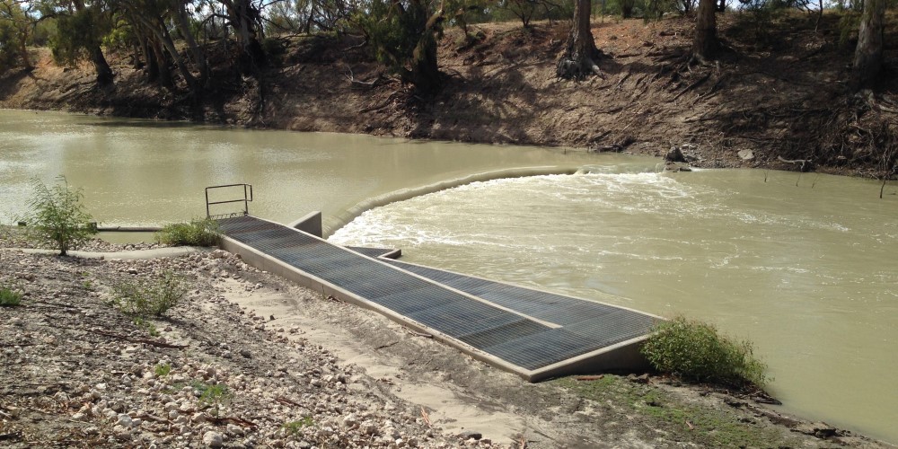
Burtundy Weir and fishway
Burtundy Weir is located 133 km upstream of the confluence of the Murray and Darling-Baaka rivers and is the first barrier experienced by fish moving upstream in the Darling River. The weir is privately owned, is approximately 1.2m high and is a fixed crest weir. The weir’s primary function is to provide a weir pool to landholders during low flow periods.
The existing Burtundy Weir fishway was first constructed in 2008. The current assessment recommended that this structure be replaced with a new fishway that meets current performance criteria.
The remoteness of the weir and the nature of the river needed to be taken into consideration as upstream and downstream water levels can vary considerably and manual fishway operations are difficult to implement at short notice.
The new Burtundy fishway has been designed to ensure that water velocity and turbulence remain within design parameters without any regular adjustments or maintenance. The fishway will be built on a maximum slope of 1 in 24. It will consist of 15 x 2 m wide and 3 m long cells (pools), with the entrance slot re-oriented to align with river flows and maximise fish attraction. The vertical slots have been designed to function over a flow range of 20 – 1000 ML/d which approaches the time when the weir would be completely submerged at a flow of approximately 1500 ML/d).