Drought monitoring in NSW
In 2008, a national review of drought policy recommended drought assistance be restructured to better help farmers plan and prepare for drought. Under the consequent Intergovernmental Agreement on National Drought Program Reform, the NSW Government established the Regional Assistance Advisory Committee (RACC) in 2013 to oversee the production of State Seasonal Updates to help landholders prepare for worsening seasonal conditions and advise the government on impacts of adverse climatic conditions.
The Department's 2015 review of seasonal conditions reports identified a need for a staged approach to seasonal conditions assessment using a comprehensive drought index (or indices). The outcome of the review was the Enhanced Drought Information System (EDIS) project to track all phases of drought and production recovery.
Aims of the EDIS project
The Enhanced Drought Information System (EDIS) aims to:
- Build drought risk awareness
- Emphasise drought preparedness
- Improve confidence in drought monitoring and “early warning”
Key features of the EDIS project
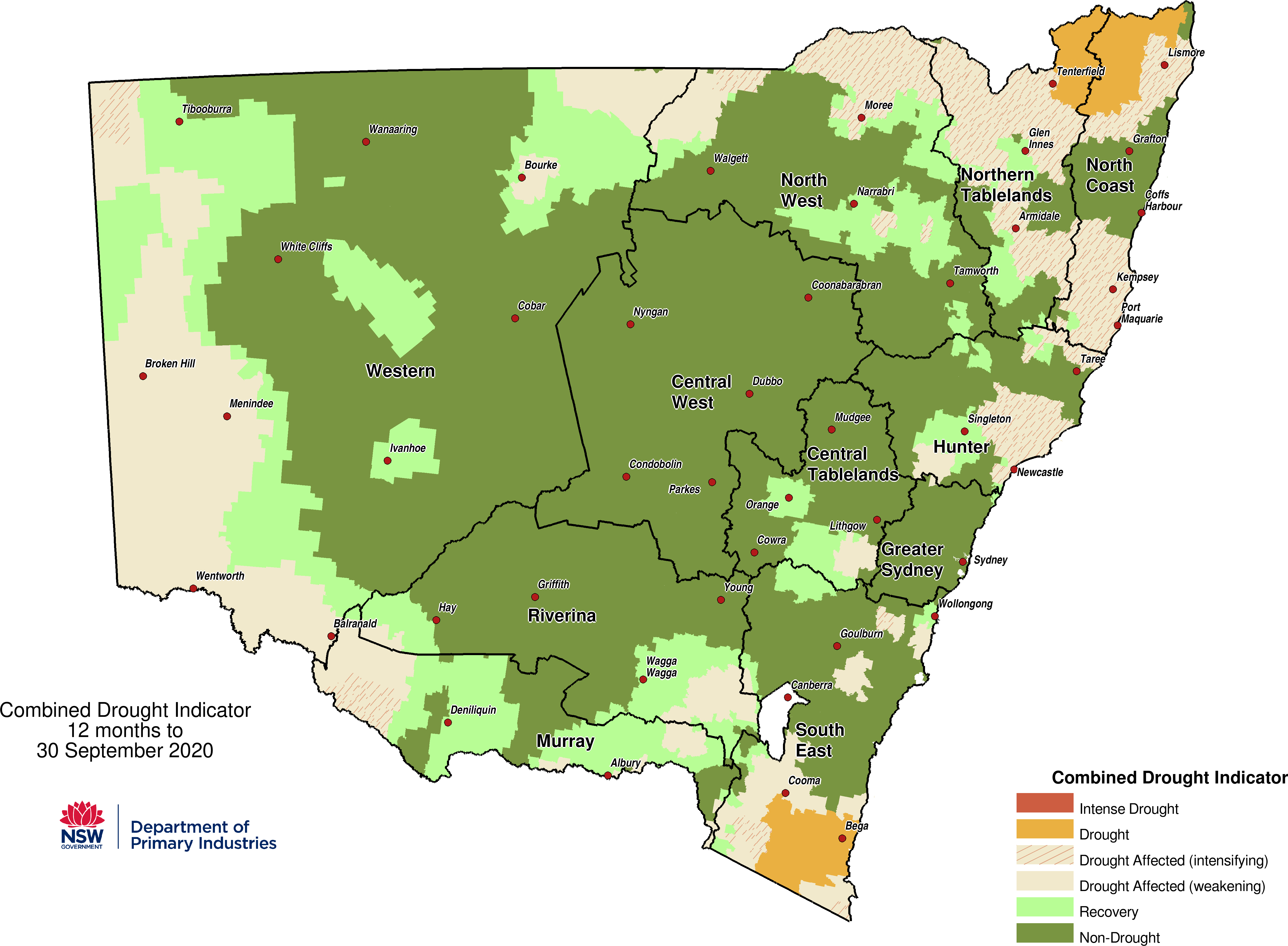
The Combine Drought Indicator (CDI) is used by the NSW Government to classify drought in New South Wales. It integrates weather, climate, soil, and land-use datasets into a single framework to help decision making.
The CDI combines meteorological, hydrological and agronomic definitions of drought using indexes for rainfall (RI), soil water (SWI), and plant growth (PGI). By using multiple indices, the CDI provides a comprehensive indicator of drought conditions in NSW. Drought is categorised into five phases:
- Non-drought
- Recovering
- Drought Affected
- Drought
- Intense Drought
Technical details of the EDIS project
EDIS is a data analytics and deployment system that sources and integrates climate and remote sensing data from a range of sources. Integration is achieved by an agricultural modelling data assimilation scheme (DPI AgriModTM) and a series of algorithms that calculate individual drought indicators and the NSW Combined Drought Indicator (CDI). New data for the CDI arrives every day, but this is for two days prior to the current date to allow time for data transfer from the field and quality control.
 used to calculate the NSW DPI Combined Drought Indicator")
The algorithms used by EDIS have been custom-engineered to efficiently undertake computationally expensive tasks, such as running the data assimilation model or ranking current events in large data sets. Custom software engineering was required to manage the high computational burden involved in operating EDIS as well as to complete the science behind its development. The baseline climate data sets have daily temporal resolution, whereas the remote sensing data has high spatial resolution (down to 250m²). Operational runs of EDIS need to be completed each day in a reliable and timely manner, within a 30-60 minute processing time.
EDIS acknowledgements and disclaimers
The EDIS portal is built, maintained and hosted by Intersect.
The data supporting EDIS is made available by third parties. Special acknowledgement is given to the Australian Bureau of Meteorology for provision of the Australian Water Availability Program (AWAP) and AVHRR NDVI data sets.
Other third party data sets are made available through the Terrestrial Environmental Research Network (TERN) under the Creative Commons – Attribution 4.0 International (CC BY 4.0) licence. Attribution and ownership of each data set are listed in the following table.
Class | Item | Source | Properties |
Climate | Australian Water Availability Program (Rainfall, Max/Min Temperature, Radiation, Potential Evaporation) | BoM | Gridded, 5km² resolution, daily |
ANU Climate | TERN/ ANU | Gridded, 1km² resolution, daily | |
Remote Sensing | MODIS and derived products | CSIRO/ TERN/ GeoScience Australia | Gridded, various resolutions, dekads and months |
AHVRR | BoM | Gridded 1km² Dekads | |
Soils | Australian Soil Landscape Grid | CSIRO/ USyd/ TERN | Gridded, 90 meter |
EDIS and CDI are trademarks owned by the NSW Department of Primary Industries and Regional Development, an office of the State of New South Wales. Copyright in EDIS and CDI vests in the State of New South Wales through the Department of Industry, Skills and Regional Development, 2016.
Any use of EDIS, CDI or any related material must be underwritten licence on terms approved by the NSW Department of Primary Industries and Regional Development. Administration and commercial fees may apply. For more information contact seasonal.conditions@dpi.nsw.gov.au
Disclaimer: The information contained in this web portal is based on knowledge and understanding at the time of development. Because of advances in knowledge, users are reminded of the need to ensure that information upon which they rely is up to date and to check currency of the information with the appropriate officer of the Department of Primary Industries and Regional Development or the user’s independent adviser.
EDIS contacts
If you are interested in obtaining EDIS data or initiating a development project, contact: seasonal.conditions@dpi.nsw.gov.au
Need drought assistance?
Visit the NSW Drought Hub.