

Forest Resources
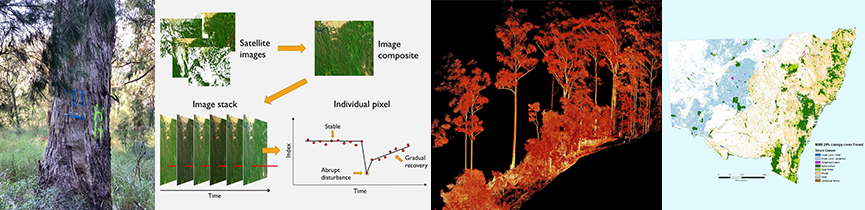
There is a growing requirement for forest managers to monitor and report on the sustainable management of their forests and timber plantations. This in turn requires the application of accurate, repeatable and affordable methodologies aimed at measuring a suite of economic, ecological and social values, as well as productivity, vegetation recovery, etc…. The Forest Resources assessment team has scientific expertise in remote sensing, GIS, spatial modelling, biometrics (including sampling design strategies) and ground measurement methodologies. Application of these expert skills result in the delivery of quantitative information on the status and trends present in NSW native forests and plantations.
Current and recent projects
NSW Forest Extent-Type spatial data for UTM zones 55 & 56 published on SEED data portal
The 2022 NSW Forest extent layer was created by the NSW DPIRD Forest Science team applying spatio-temporal analysis of the 2017-2022 National Forest and sparse woody vegetation data (Version 7.0 - 2022 Release) (Department of Climate Change, Energy, the Environment, and Water's). The data is available on data.gov.au. The dataset was further analysed and masked to exclude non-forest areas and create a forest extent layer with a 20 percent canopy cover for the NSW UTM Zones 55 & 56. The mask layer includes various datasets such as NSW Land use 2017, State Vegetation Type map (SVTM), Land Zoning, Water body, etc. The DPIRD Plantation unit's Authorised plantation layer (current as Aug 2024) was used to characterise forest types, i.e. Native forest and Plantation.
The Forest extent data consists of two forest types: Native forest and Plantation. The data has been published on SEED data portal, click here to access the dataset and associated map service.

For more information please email masoomeh.alaibakhsh@dpi.nsw.gov.au.
NSW Land Tenure spatial data published on SEED data portal
A comprehensive NSW Land Tenure layer has been developed, integrating the latest and most reliable datasets sourced from various governmental authorities and departments. To the best of our knowledge, this layer offers detailed mapping of recent updates and changes in land tenure across the state. It includes information on land allocations, ownership transformations, and management updates, providing an up-to-date and accurate representation of land tenure in New South Wales.
The land tenure data consists of seven Tenure classes each class covering various tenure types. Tenure Class presents tenure classification of the dataset as Crownland-Leasehold; Crownland-Other; Indigenous Owned; National Park; Private; State Forest; and Unresolved Tenure lands. The data has been published on SEED data portal, click here to access the dataset and associated map service.

For more information please email masoomeh.alaibakhsh@dpi.nsw.gov.au.
NSW forest extent interactive reports
The Forest Science Resources team has produced interactive reports on the NSW forest extent across various administrative boundaries. The reports provide detailed calculations of forest area by tenure across key forestry administrative boundaries such as IBRA, IFOA & RFA regions. Visit the NSW Forest area by Tenure dashboards page for more details.
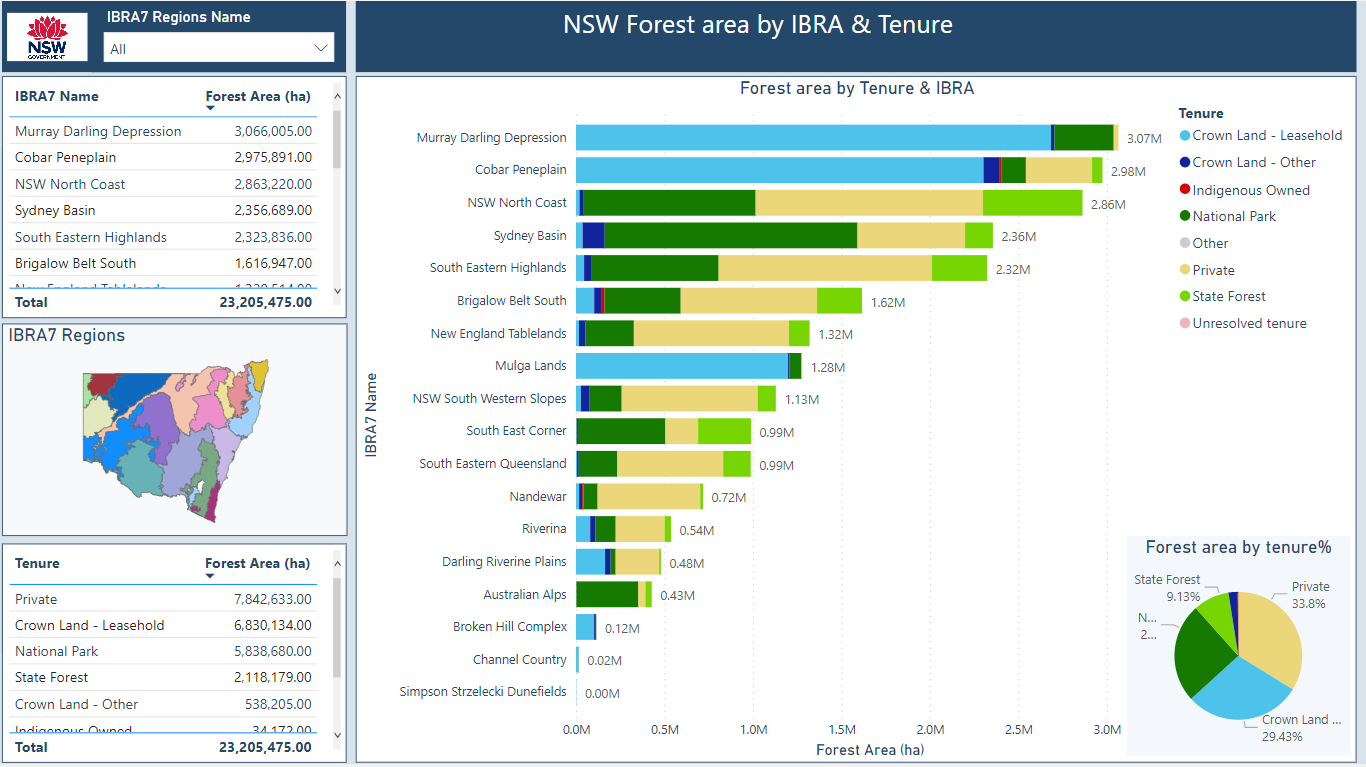
The team will be producing more dashboards in the near future.
Mechanical Fuel Load Reduction Trials
The Mechanical Fuel Load Reduction Trials are investigating whether mechanical fuel load reduction can reduce bushfire risk in an economical, socially acceptable and environmentally sound manner around key assets, such as conservation areas or townships, where prescribed burning is undesirable for a range of reasons. Final report coming soon.
Characterising native forest structure from co-incident terrestrial and airborne LiDAR
This project, funded in part by Forest Wood Products Australia (FWPA), investigated methods to link ground-based 3D point cloud LiDAR data with high-density aerial LiDAR and potentially satellite-based (GEDI) LiDAR data for the purpose of characterising the complex structure of moist eucalypt forests compared to manual collection methods. Report submitted to FWPA, FWPA project PNC546-2021 awaiting publication.
The project is a proof-of-concept study to determine the feasibility of:
- Integrating terrestrial mobile laser scanning (MLS) point cloud data with high quality airborne laser scanning (ALS) LiDAR data.
- Extracting meaningful metrics which can be scaled up for operational assessment, modelling and monitoring of moist eucalypt forests with complex canopy and understorey structure.
Structural information can be used in the following operational areas:
- Ecology - Tracking changes in forest structure over time with linkages to other metrics (e.g. Biodiversity Assessment Method scores). Metrics extracted could also be used as inputs to species habitat modelling.
- Stand and tree-level resource assessment – identifying individual tree locations and measuring stem diameters and volumes with a high degree of accuracy at the plot (0.1ha) level.
- Fuel load modelling – vertical structural metrics of fuel level and arrangement that will contribute to fire behaviour modelling, planning for suppression and prescribed burning and monitoring of post-fire recovery.
Services and Reports to NSW Natural Resources Commission (NRC) Forest Monitoring and Improvement Program (FMIP)
- Forest stratification and processes for statistically robust forest monitoring plot sampling
- Forest monitoring field data collection manual and trialling of the same
- Provision of data and data analysis on multiple topics
- Lead of Project FE1: Baselines, drivers and trends for forest extent, condition and health
DPI Forest Monitoring Feasibility Project (July 2017 to July 2019); replaced by NRC FMIP and fed into that program
- Comprehensive data collected on 58 Forest Monitoring plots to Montreal Criteria and indicators
- Tested on 3 distinct sub-bioregional IBRA’s on State Forests, Private property and National Parks with co-incident LiDAR transects
- Testing processes, analysis and data collection logistics
Private Native Forestry R&D services for Local Land Services
This project reports to LLS on the following themes on the Private Forests of NSW
- Remote data collection
- Forest Yield Association Groups (YAG) assessment and Mapping
- Canopy change modelling
- Forest attribute modelling
- On-ground data collection and monitoring
Private Native Forests on the North Coast (2018)
This project assessed extent and status of private native forests (PNF) on the North Coast. The project saw more than 600 landholders, contractors and industry representatives interviewed or surveyed, as well as more than five million hectares mapped, and one million hectares of timber resources assessed using aerial photography.
- Native forest type mapping
- Valuing private native forest for timber production
- State and condition of the forests
- Planning and regulatory instruments that interact with private native forestry
- Survey of private native forest landholders
- Survey of timber harvesting contractors and wood processors
Publications
The Forest Resources team has published papers and reports in many research areas including but not limited to:
- Forest assessment and monitoring;
- Satellite imagery applied to map and assess forest disturbance including fire impact;
- Application of LiDAR to characterise forest structure;
- Satellite imagery time series analysis;
- Native forest timber production availability and suitability;
- Development of field assessment methodologies; and
- GIS derived forest products and maps.
Contact Details
John Samuel | Leader & Project Forester
john.samuel@dpi.nsw.gov.au
Masoomeh Alaibakhsh | Spatial Modeller
masoomeh.alaibakhsh@dpi.nsw.gov.au
Mingzhu Wang | Remote Sensing Scientist
mingzhu.wang@dpi.nsw.gov.au
Andres Hernandez Gutierrez | Data Scientist
andres.hernandezgutierrez@regional.nsw.gov.au
Christine Stone | Visiting Research Scientist
christine.stone@dpi.nsw.gov.au
