SA Vic Mallee Regional Summary

The region
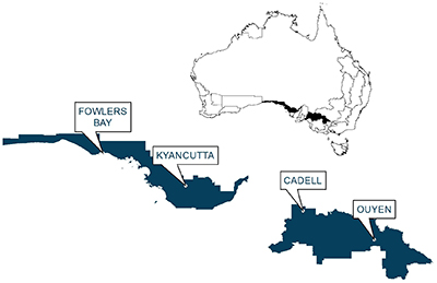
The SA Vic Mallee agroecological zone is in two separate sections. The western section starts near Lock on the upper Eyre Peninsula and extends west to near the Head of the Bight. The eastern portion starts near Murray Bridge and extends east to around Birchip. Rainfall in the zone ranges from > 500 mm annum-1 in the west to < 400 mm annum-1 in the east and rainfall seasonality is winter-dominant. Boundaries for the zone are shown in Figure 1.
Modelling regional practices
Producing models that reflect all farming practices throughout a region is difficult so “common practice” models for wheat, barley and lupins for the region were produced. A wheat crop with a 1.7 t ha-1 yield and 32 kg of fertiliser N applied ha -1, a barley crop with a yield of 1.8 t ha-1 with 4 kg fertiliser N ha -1 applied and a lupins crop with a yield of 1.2 t ha-1 and 5 kg of fertiliser N ha -1 applied were modelled. The key assumptions of these models were that;
- Only one pass was made at sowing
- Split fertiliser applcations were used for wheat crops
- It was assumed that all crops had three fallow herbicide applications and wheat and barley had one in-crop herbicide application while lupins had two. Lupins also had one fungicide application.
- Stubble was retained
Impact indicators
Hydrogen ion impacts estimate the release of hydrogen ions to the soil associated with crop production. A negative value indicates a reduction in soil acidity whereas a positive value indicates an increase in soil acidity. Soil erosion is an estimate of soil loss that occurs during the production of the crop. The depth of soil lost will depend on many things but an approximate conversion is that 1.5 t of soil loss equals 1 mm of soil. Global warming impacts are the release of greenhouse gases to the atmosphere expressed as carbon dioxide equivalents (CO2-e), Eutrophication impacts are the release of phosphorous to the environment and are expressed as phosphate equivalents and Particulate Matter impacts are the release of fine particles less than 2.3 micrometres in diameter.
Benchmark results
Results below in Table 1 show the environmental impacts of producing a t of wheat, barley or lupins in the region. An absence of lime use in the region resulted in an increase in free hydrogen ions in the soil for all crops and soil erosion was estimated at between 5.1 and 6.4 t soil loss t product-1. Global warming impacts indicate that the emissions intensity associated with the production of these crops ranged from between 103 and 335 kg CO2-e, Eutrophication impacts of between 0.8 and 2.3 kg PO4-e and Particulate Matter impacts of between 0.11 and 0.32 kg of < 2.5 µm particulate matter t product-1.
Table 1: Hydrogen ion changes, soil erosion and Global Warming, Eutrophication and Particulate matter impacts associated with the production of wheat, barley and lupins in the SA Vic Mallee agroecological zone.
Hydrogen ions | Soil erosion | Global warming | Eutrophication | Particulate matter | |
|---|---|---|---|---|---|
(kg H+) | (t soil loss) | (kg CO2-e) | (kg PO4-e) | (kg PM2.3) | |
Wheat | 2.25 | 5.35 | 334.93 | 2.25 | 0.32 |
Barley | 0.98 | 5.08 | 169.72 | 0.81 | 0.11 |
Lupins | 1.36 | 6.38 | 102.59 | 1.03 | 0.14 |
Greenhouse gas emissions
The emissions profile of all three crops are shown below in figure 2. The greatest sources of emissions for wheat production were the production and use of fertiliser. For barley and lupin production, the greatest source of emissions was the breakdown of residues due to relatively low rates of fertiliser being used.
Figure 2: Greenhouse gas emissions profile for the production of wheat, barley and lupins in the SA Vic Mallee agroecological zone.Greenhouse gas mitigation strategies
Mitigation strategies tested for the region were;
- Sustainable intensification
- Implementation of variable rate fertiliser technology
- Changing a wheat-wheat rotation to a legume-wheat rotation
More information on the assumptions used to test these strategies and how they might reflect individual enterprises are available on the Mitigation strategies page.
Results (figure 3 below) indicate that emissions of a t of wheat can be reduced by;
- 15% through the implementation of sustainable intensification
- 16% by implementation of variable rate fertiliser technology
Results also indicate the replacing a wheat crop with a legume crop in a two-crop rotation can increase greenhouse gas emissions intensity by 124%.
Figure 3. Reductions in greenhouse gas emissions for wheat production when grown with sustainable intensification, variable fertiliser and legume - wheat mitigation strategies in the SA Vic Mallee agroecological zone.
Accessible content
Visit accessible versions of the raw data used to generate these charts.
More information
Dr Aaron Simmons
Orange Agricultural Institute
1447 Forest Road
Orange NSW 2800
P: 02 63913894
E: aaron.simmons@dpi.nsw.gov.au

