

Fish friendly councils top tip 2
2. Help protect key fish habitat in Council planning processes
Key fish habitats are areas which support or are likely to support native fish. These areas include, but are not limited to, perennially flowing rivers, wetlands, estuaries and oceanic bays, intermittently flowing creeks, billabongs and lakes and any waterbody known or likely to support threatened species. Councils use local planning regulations to manage land use and development within their local government areas.
When reviewing these regulations council can identify key fish habitat and land use zones and clauses to ensure these important habitat sites are managed according to best practice guidelines. State agencies can assist with this habitat identification process and provide recommendations for best practice.
Council can ...
- protect key fish habitat within their local planning regulations
- ensure that land use planning and development assessment processes avoid or minimise impacts on key fish habitat. More about key fish habitat in your area.
- ensure works avoid or minimise impacts on key fish habitat. See the Council and developer tool kit.
Case Study - Assisting in the recovery of the endangered Oxleyan Pygmy Perch, Richmond Valley Council.
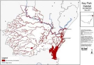
image: I&I NSW
The Key Fish Habitat map for Richmond Valley local government area is extensive, particularly in the coastal region near the township of Evans Head. This mapping reflects the distribution of Oxleyan pygmy perch (OPP). OPP is a small freshwater fish listed as ‘endangered’ under the Commonwealth EPBC Act 1999 and the NSW Fisheries Management Act 1994. The threatened species recovery plan for OPP identifies the main threats to OPP to be from coastal development, water pollution, habitat degradation and competition with the introduced species Gambusia holbrooki. In recognition of these threats, Richmond Valley Council has developed a stormwater drain management plan and undertaken a proactive role in the rehabilitation of OPP habitat. More...
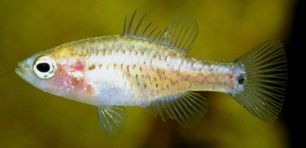
THe Oxleyan pygmy perch. Image: Gunther Schmida
See also
- 1. Find out about your local fish populations
- 3. Ensure council infrastructure is fish friendly
- 4. Treat stormwater prior to discharge
- 5. Protect and manage buffer areas
- 6. Maintain and enhance public reserves for river health
- 7. Collaborate with your neighbouring councils
- 8. Support local groups working on fish friendly projects (for example: Rivercare, Landcare, Indigenous groups, Fishing clubs)
- 9. Educate your local community about fish and river health
- 10. Promote your fish friendly work to the wider community
