

Other restrictions on areas of operations
The waters specified in the table below (Schedule 3 of the Ocean Hauling Share Management Plan) are waters in which the class of commercial fishing that consists of the method of fishing specified in Column 2 is prohibited during the period specified in Column 3 next to the waters concerned.
| Area Affected | Method of fishing prohibited | Period | Location maps |
|---|---|---|---|
Trial Bay South West Rocks | |||
| The whole of the waters within a 100 metre radius of any Maritime Authority of NSW emergency buoy situated at or near the following point at Trial Bay: 30°52.645′S, 153°03.175′E and 30°52.664′S, 153°03.106′E. | Any method involving the use of the following: (a) a purse seine net, (b) a pilchard, anchovy and bait net (hauling). | All year. | 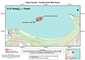 (PDF, 137.74 KB) (PDF, 137.74 KB) |
Narrabeen - Black Road Bait Ground | |||
The whole of the waters known as the Black Road Bait Ground, enclosed by a line drawn east from the eastern extremity of North Narrabeen Head for a distance of approximately 1650 metres to the 30 fathom depth contour, then southerly along the 30 fathom depth contour to a point approximately 2650 metres due east of South Narrabeen Surf Life Saving Club, then by a line drawn west to that Club. | Any method involving the use of a purse seine net. | All year. | 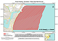 (PDF, 120.42 KB) (PDF, 120.42 KB) |
Clovelly Beach | |||
The whole of the waters of Clovelly Beach (also known as Little Coogee Bay) westwards of a line drawn from the easternmost point of the headland at Clovelly Surf Club, north to the easternmost point of Shark Point. | Any method. | All year. | 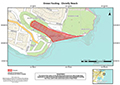 (PDF, 132.53 KB) (PDF, 132.53 KB) |
Port Hacking | |||
The whole of the waters of that part of Port Hacking north of a line drawn from the southern extremity of Hungry Point north-easterly to a point on the northern foreshore of Port Hacking due south of the Bass and Flinders Memorial. | Any method. | The period from 6am Saturday to 6am Monday, or to 6pm Monday if Monday is a public holiday, in each week. On any weekday (other than a Monday) that is a public holiday: the period from 6am to 6pm. | 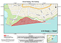 (PDF, 127.74 KB) (PDF, 127.74 KB) |
Shell Harbour | |||
The whole of the waters of that part of Shell Harbour north-west of a line drawn from the southern extremity of the northern breakwater to the eastern extremity of the southern breakwater. | Any method | All year | 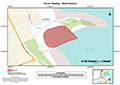 (PDF, 148.07 KB) (PDF, 148.07 KB) |
