Monitoring Koalas in the public Hinterland Forests of North-east NSW and the effect of 2019 fires on the meta-population
Monitoring is fundamental to improving the management of threatened species. There is much speculation, but few available data on trends in koala populations. DPI Forest Science has monitored annually the koala metapopulation of the hinterland forests of north-east New South Wales since 2015.
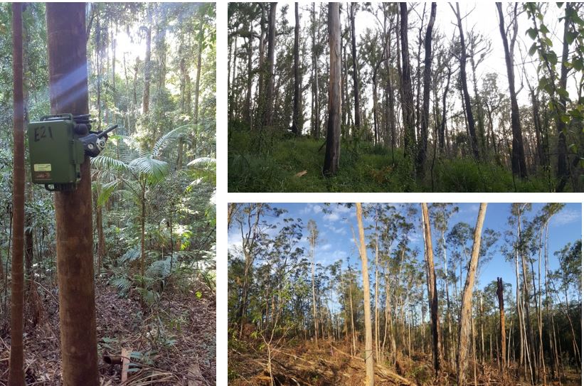
The north-east forest acoustic monitoring program evolved out of a three-year study of koala occupancy in hinterland forests between 2015-2017 (Law et al. 2018). This study used novel passive acoustic methods to record koala bellows and site occupancy at 224 sites across a variety of forest types in state forests and national parks (public forests). An extensive area (1.7 million hectares) of better-quality koala habitat was targeted for surveys using a model derived for the study area (Law et al. 2017), but some sites in poorer quality habitat were also surveyed.
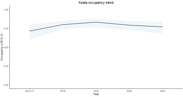
Statistical analysis of these data identified a stable trend in koala occupancy for the north-east metapopulation over seven years from 2015 to 2021. Median probability of occupancy remained high throughout this period at ~ 0.75, indicating most sites were occupied. Together with the large extent of suitable habitat in the region, these results are indicative of a large meta-population spread across state forests and national parks. The median occupancy estimate was derived by accounting for imperfect detection and the different environmental conditions (e.g. elevation) at each monitoring site. Unexpectedly, there was no signal of a decline in koala occupancy in 2018 during the most recent NSW drought or immediately after the 2019 wildfires (see below for more details). Confidence intervals were narrow, meaning there is a high level of confidence in the koala occupancy estimates in this study.
.
Explore an Interactive Report of Koala Monitoring Sites
This report spatially shows 224 monitoring sites in the hinterland forests of north-east NSW overlaying a koala habitat model for the region (Law et al. 2017). Zoom in on the map and click on sites of interest to show graphed trends in occupancy since 2015-2021 at that site. These are modelled trends in conditional occupancy (a value of 1 means the site was occupied) for each site based on relationships with covariates. It should be noted that not every site was monitored in each year. The extent of high severity black summer fires (the major disturbance in this time period) and the drought period can also be viewed in the graph. Along with the mapped sites, the broad classes of habitat quality surrounding each site is shown.
How to Use the Interactive Report
- Click on 'View interactive content' to get started;
- To generate a graph detailing koala habitat and occupancy of your site of interest, either click on a site symbol on the interactive map or use the list of sites on the left and choose your site of interest;
- For clearing the selection, either use the 'Clear selections' icon at the top of the list or unclick the site in the list (this will zoom the map back to full extent), or simply click on another site in the map (this will update the graph to match the newly selected site);
- Note: for use on small mobile devices, after clicking the 'View interactive content', use the zoom bar below the map and zoom to ~60%, then use the pan left-right bar to pan right to the graph relating to the active site selected.
The koala habitat suitability model categories are:
- Yellow: Low suitability
- Green: Medium suitability
- Blue: High suitability
- Dark blue: Very high suitability
Background to Monitoring
Acoustic monitoring is undertaken in the spring breeding season at a subset of sites (~ 60 sites per year). About 50 sites were sampled immediately after the extensive bushfires in 2019 and a larger complement was completed in 2020. The program comprises four years of pre-fire data representing a strong baseline for ongoing koala monitoring and an assessment of the impacts and recovery from the 2019 fires in these forests. Given naturally low densities of koalas, we expect just one male koala to occupy the area sampled by each acoustic sensor (see FAQs for more details).
As with earlier years, the 2019 and 2020 field programs were across state forest and national park and were undertaken by Forestry Corporation of NSW and NSW DPI. Funding for these latter years was provided from the NSW Forest Monitoring and Improvement Program, overseen by the Natural Resources Commission and a steering committee including NSW agencies and experts from leading universities.
An extensive dataset has accumulated through the program comprising:
- 224 sites
- > 25,000 hours of nocturnal recording over > 2,500 nights;
- > 12,000 bellows identified so far
Identification of koala bellows was undertaken in collaboration with the Ecoacoustics lab at Queensland University of Technology using an algorithm that identifies the low frequency, oscillating nature of the koala bellow and a DPI developed recogniser. These were then manually validated.
It is important to point out that stable occupancy of a metapopulation can include increasing and decreasing subpopulations, whereby connected populations that go extinct can be recolonised. Monitoring over such a regional scale is important for assessing the changing status of species together with monitoring that focuses intensively on individual populations. Also, in north-east NSW many koala subpopulations are under threat along the coast from increasing development. These coastal populations are not part of the hinterland forests monitored in this study.
Interpreting the Impact of 2019 Fires
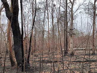
 The continued stable trend in occupancy after fire needs to be interpreted carefully. Firstly, our monitoring attempted to be representative of the fire extent on koala habitat. Given about 30 % of modelled koala habitat burnt on the north coast, we accordingly monitored koalas at 16 burnt sites (33 % of all sites monitored in 2019) with varying degrees of severity and fire extent, which we assessed in a 1 km radius around each site using Fire Extent and Severity Mapping (FESM; Department of Planning, Industry and Environment 2019). Ten sites mostly experienced high severity fire and six mostly experienced low/medium severity fire.
Overall, koalas were detected at 81 % of the 16 burnt sites sampled, which was equivalent to the detection rate at unburnt, but drought afflicted sites, in 2019. All three high severity fire sites without koala detections had high severity fire extents of >50 % of their surroundings. Two of these were in Kiwarrak State Forest and a third was in Bellangry State Forest. At other burnt sites where koalas were detected, refuge areas occurred in the surrounding landscape (i.e. high fire severity covered < 50 % of the surrounding landscape) or fire severity was lower. Example sites where this was the case included parts of Kiwarrak State Forest, Royal Camp State Forest, Myrtle State Forest and Bungawalbin National Park, among others.
It is also important to acknowledge that these data describe koala occupancy for the metapopulation, not local density at a site. There is no doubt many occupied sites experienced a severe decline in koala density. We have quantified this scenario at three sites by estimating density before and after the fires, one being a low severity fire, one moderate severity and one high severity. Analysis of these results revealed that a large impact occurred where fire severity was high and widespread persistence was recorded where severity was low (Law et al. 2022).
Other post-fire surveys either focused mostly on burnt sites, targeting sites with a pre-fire assessment (Phillips et al. 2021) or sampled unburnt as well as a range of fire severities (DPIE 2020). These surveys achieved a mixed response in relation to detecting koalas, though koala detection dogs confirmed persistence at varying levels in all the study areas sampled (DPIE 2020). An important distinction between DPI’s regional acoustic surveys and local site-based surveys (e.g. detection dog surveys cover ~ 1 ha) is that acoustic sensors sample koala presence over a much larger area (~30 ha) and so may be more likely to encompass fire refuges.
In summary, the metapopulation of koalas in north-east of NSW has been resilient to the 2019 wildfires at the regional scale, with 70 % of habitat remaining unburnt and, where it did burn, there was often a mosaic of fire severity and extent, including unburnt refuges. While there is no doubt particular local populations of koalas were severely impacted, especially where higher severity fires were more extensive, post-fire surveys suggest that this rarely resulted in local extinction, at least in the hinterland forests with high connectivity that were monitored in this and other studies.
Climate change is predicted to lead to greater fire frequency, which is expected to burn a cumulatively greater extent of koala habitat in the future. Greater fire frequency is consequently predicted to increase fire impacts on koalas as refuge areas may shrink and koalas have less opportunity to recolonise. Refuges of koala habitat that avoided past high frequency fires have previously been mapped in north-east NSW (Law et al. 2017), but this should be updated to include the 2019 fires.

FAQs
What is a metapopulation?
A metapopulation consists of a group of spatially separated populations of the same species which interact at some level.
What is site occupancy?
Site occupancy is a standard population surrogate used by ecologists to compare different areas or trends in populations over time. It differs from presence/absence data in that modelled occupancy accounts for imperfect detection of the study species. Typically, many sites are surveyed to characterise occupancy in a metapopulation.
What are koala bellows?
Bellows are primarily produced by adult male koalas both to avoid male-male interactions by functioning as a signal of body size and to attract females, and thus they indicate breeding activity in a population. Given bellows are mostly produced by adult koalas, they are expected to generally represent resident individuals.
What is the size of a survey site?
One acoustic sensor samples an area slightly smaller (~ 30 ha) than the expected home range of one adult male koala. Male home ranges do increase during the breeding season, however current tracking data demonstrates they are generally smaller than the detection zone of each sensor and confined to stable areas (DPI unpubl. data).
References
Department of Planning, Industry and Environment (2019). DPIE Fire Extent and Severity Mapping FESMv2 Factsheet (December 2019). NSW Department of Planning, Industry and Environment, Sydney.
Department of Planning, Industry and Environment (2020). Post-Fire Koala Surveys. A Saving our Species Project. Northeast NSW.
Law B, Caccamo G, Roe P, Truskinger A, Brassil T, Gonsalves L, McConville A, Stanton M (2017) Development and field validation of a regional, management-scale habitat model: A koala Phascolarctos cinereus case study. Ecology and Evolution 7:7475–7489. https://doi.org/10.1002/ece3.3300
Law BS, Brassil T, Gonsalves L, Roe P, Truskinger A, McConville A (2018) Passive acoustics and sound recognition provide new insights on status and resilience of an iconic endangered marsupial (koala Phascolarctos cinereus) to timber harvesting. PLoS ONE 13(10): e0205075. https://doi.org/10.1371/journal.pone.0205075
Phillips, S., Wallis, K. and Lane, A. (2021), Quantifying the impacts of bushfire on populations of wild koalas (Phascolarctos cinereus): Insights from the 2019/20 fire season. Ecol Manag Restor, 22: 80-88.


