

Koala tracking and surveys
Koala tracking research
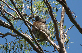
A new koala tracking project began in 2018 and is still underway in north-east forests of NSW on the mid north-coast.
The project is using GPS collars on koalas to track their movements throughout the forest which will enable DPI researchers to look at the effectiveness of koala protections in State forests and relative use of young regenerating eucalypts after harvesting compared to mature forest that is excluded from harvesting.
Eight Koalas have been collared so far providing outstanding information on what tree species and sizes offer important browse as well as other aspects of habitat use like use of ridges vs gullies.
The DPI Forest Science research is partnered with the Port Macquarie Koala Hospital and Forestry Corporation.
The findings of the research will be considered by the Natural Resources Commission who is independently commissioning and overseeing other research projects investigating how koalas respond to regeneration harvesting on state forests as part of the NSW Koala Strategy.
Status of koalas in north-east NSW forests
Between 2015 and 2017, DPI forest scientists undertook a large-scale study on the status and response of koalas to timber harvesting in the north-east forests of NSW. Koalas are surprisingly difficult to survey due to their low densities and cryptic nature, especially in tall remote forests. Surveys were focused on forests of the hinterland, ranges and tablelands of North East NSW, rather than the coastal strip where urbanisation is the main threat to koala populations.
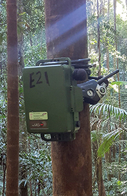
SongMeters were deployed at nearly 200 sites over 7-14 nights to record male bellows over three breeding seasons (>14,500 hours of recording). The project relied on cutting-edge software developed by the Queensland University of Technology to automate the call detection process from thousands of hours of recordings.
Results showed that, on average, 65 per cent of survey sites (the small zone surrounding each SongMeter) were occupied by at least one koala, which was much higher than expected based on previous surveys using alternative methods. We found that occupancy was influenced by elevation, cover of important browse trees, site productivity and extent of wildfire in the last 10 years.
Occupancy was not influenced by timber harvesting intensity, time since harvesting, land tenure, landscape extent of harvesting or old growth forest extent. The highest bellow rate (23 calls per night) across all sites surveyed was recorded at a site in Kiwarrak State Forest that was recently heavily harvested (though with a mosaic of harvest exclusions). Overall, forest treatment had no statistically significant effect on bellow rate.
Extrapolation of occupancy across modelled habitat indicates that the hinterland forests of north-east NSW support a widespread, though naturally low density koala population that is considerably larger than previously estimated.
A paper detailing the results of this study has been published (Law et al. 2018).
Predictive habitat modelling
Predictive models that map species distributions are a useful management tool for guiding and informing on-ground management of threatened species. Forest scientists at DPI have developed a model for the koala (Phascolarctos cinereus) in North East NSW. The model is used by the Environmental Protection Authority to predict where areas of differing habitat quality for koalas are likely to occur.
The focus was to help guide decisions on timber harvesting in forests by identifying likely koala habitat. Ultimately, this could lead to better on-ground implementation of koala management for public state forests and private forestry areas.
Publications
- Law B, Caccamo G, Roe P, et al. (2017) Development and field validation of a regional, management-scale habitat model: A koala Phascolarctos cinereus case study. Ecology and Evolution 7:7475–7489
- Law BS, Brassil T, Gonsalves L, Roe P, Truskinger A, McConville A (2018) Passive acoustics and sound recognition provide new insights on status and resilience of an iconic endangered marsupial (koala Phascolarctos cinereus) to timber harvesting. PLoS ONE 13(10): e0205075.
- Law, B., Gonsalves, L., Bilney, R., Peterie, J., Pietsch, R., Roe, P. and Truskinger, A. (in press) Using passive acoustic recording and automated call identification to survey koalas in the southern forests of New South Wales. Australian Zoologist.
