

Hunter / Central Rivers catchment
The Hunter-Central Rivers catchment is an area of about 37 000 square kilometres of the east coast of NSW.
The region's major waterways are the Manning, Karuah and Hunter rivers and the coastal waterways of Wallis Lake, Port Stephens, Lake Macquarie, Tuggerah Lakes and Brisbane Waters.
Fish habitat and species diversity
A description of the aquatic biodiversity of the region is available as part of the project to assess the barriers to fish passage.
Estuarine Habitat Maps
There is now a complete coverage for the 154 NSW estuaries which contain one or more of the important estuarine habitats such as seagrass, mangrove and saltmarsh. These maps will provide coastal Local Land Services and Local, State and Australian Governments with information to support natural resource condition targets and to monitor the effectiveness of management actions against those targets.
These maps have been produced as part of the Key Fish Habitat Mapping initiative.
Barriers to fish passage
Fish movement can be restricted in some areas of the catchment due to instream structures.
A weir assessment project has been funded by the NSW Environmental Trust to investigate the impact of weirs on environmental flows, water quality and fish passage. The project will build on the outcomes of the NSW Weir Review, under the NSW Weirs Policy (1997), by undertaking detailed reviews of 80 high-priority weirs for remedial action within NSW. The reviews will facilitate future on-ground works by addressing all associated social, ecological, cultural and logistical issues that surround the modification of existing barriers and provide a clear process towards mitigating their environmental impact.
More information is available about this project and about the assessment of road crossings as barriers to fish passage.
Barrier removal projects
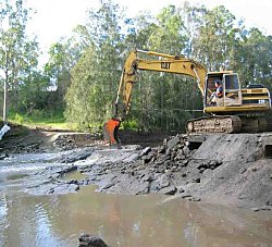
Case Study - The Branch River Crossing
The Branch River Crossing is located near Port Stephens on the Karuah River catchment, approximately 22 km north-east of the township of Karuah, NSW. The crossing was situated on a natural rock bar at the upper end of the tidal limit. The removal of the Branch River Crossing was part of a larger weir removal project being undertaken by DPIRD, WWF Australia and the NSW Environmental Trust. This project aims to increase public awareness of the environmental effects of in-stream barriers. It provides a framework to facilitate community based weir removal projects and demonstrates the ecological benefits of improved river health.
An excavator and rock breaker were used to break the concrete cap on the Branch River Crossing. A couple of metres of the crossing was left near the edge to maintain bank stability. In less than four days fish passage was re-instated to approximately 30km of the Branch River for the first time in 52 years.
Williams River fishway - Hunter Water Corporation
Hunter Water Corporation in partnership with NSW DPIRD and the Department of Infrastructure, Planning and Natural Resources completed the construction of a full-width rock ramp fishway at Bandon Grove on the Williams River.
Stroud weir fishway, Karuah River
The Stroud Weir was modified to incorporate a rock-ramp fishway in 2006. A pictorial case study of the whole process of constructing the fishway is available.
Protection and rehabilitation of aquatic habitat
NSW DPIRD is working with Oceanwatch on the Tide-to-Table project.
See ...
- Aquatic biodiversity report - HCR (PDF, 161.3 KB)
