

Batemans Marine Park

Batemans Marine Park on the NSW south coast extends from the most northerly point of Murramarang Beach near Bawley Point to the southern side of Wallaga Lake entrance at Murunna Point.
The marine park includes:
- approximately 850 km2, extending from the three-nautical-mile offshore limit of NSW waters to the mean high water mark within all rivers, estuaries, bays, lagoons, inlets, and saline and brackish coastal lakes (excluding Nargal Lake);
- offshore islands including Tollgate Islands and Barunguba Montague Island.
The park was established in April 2006 and its zones and management rules commenced in June 2007. Changes to rules regarding fishing from some ocean beaches and headlands were introduced in June 2018.
Map of Batemans Marine Park
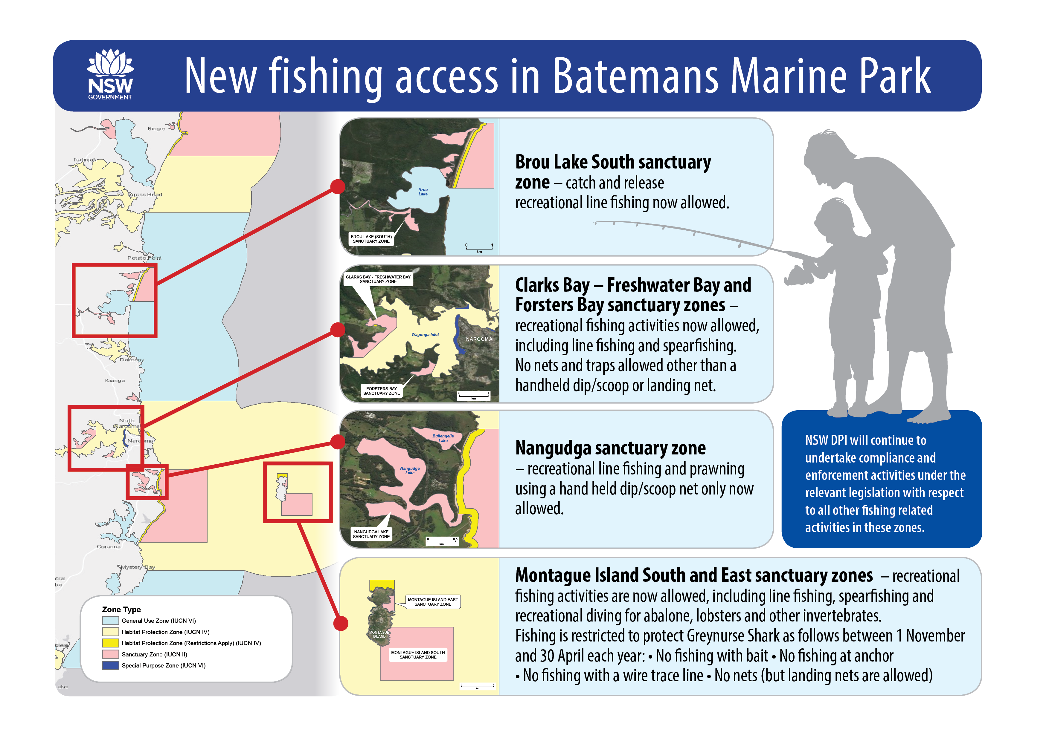
Recreational fishing in Batemans Marine Park
In December 2019, the NSW Government announced changes that increased recreational fishing access in sanctuary zones in 6 areas of the Batemans Marine Park. For further details, check out the Frequently Asked Questions (FAQs) below. All other sanctuary zones within the Batemans Marine Park remain closed to fishing.
- FAQs - Recreational fishing in Batemans Marine Park - 12 December 2019
- Infomap (PNG, 1382.75 KB)
The marine park Zoning Map (PDF, 3458.46 KB), User Guide (PDF, 2029.36 KB) and the FishSmart NSW app provide information about the current zoning arrangements and management rules in the park.
Some of the content on this page may not be fully accessible. To obtain an accessible version of this content please email marine.environment@dpi.nsw.gov.au
Why Batemans Marine Park is unique
An outstanding feature of the park is the large expanses of rocky reef that support a diverse array of fish, invertebrates and algae. Rocky shores, offshore rocky reefs, kelp beds, seagrasses, mangroves, sponge gardens, sandy beaches, estuaries and open waters are key habitats.
Within the park, Barunguba Montague Island Nature Reserve is:
- a breeding place for over 40,000 sea birds;
- an Australian and New Zealand fur seal haul-out site;
- a nesting location for three shearwaters (mutton bird) species, crested terns and silver gulls;
- a nesting site for 8000 to 12,000 little penguins – Australia's only native penguin.
Large aggregations of morwong, trevally and snapper are found off Montague Island, along with pelagic species such as kingfish, albacore and yellowfin tuna that follow the warmer currents.
Many of the park's highly significant coastal lakes and lagoons, which include Durras, Brunderee, Tarourga and Brou Lake, have been recommended for protection. These smaller lakes intermittently close and open to the sea, creating the unique environments predominantly found along the state's south coast.
The park lies within the country of the Yuin people, who maintain a strong connection to the area's sea country.
Things to do and see
Batemans Marine Park offers plenty of activities and exploring. Check out what to do and see:


