

Waters in which ocean hauling is prohibited
The waters within 200 metres of the mean low water mark specified in the table below, (Schedule 1 of the Ocean Hauling Share Management Plan) are waters in which the class of commercial fishing that consists of the taking of fish by commercial fishers in the fishery is prohibited. The prohibition does not apply to the use of the garfish net (hauling) or pilchard, anchovy and bait net (hauling) where those nets are cast from and hauled back to a boat, in waters that are adjacent to a headland that is at the end of a beach specified below.
Region 1 - Upper North Coast
Location | Description of waters | Location maps |
|---|---|---|
Bogangar Beach | The whole of the waters adjacent to the beach from Norries Head generally northwest along the length of the beach for a distance of 400 metres (identified by a group of unnamed rocks). |  (PDF, 109.29 KB) |
Crabbes Creek Beach (also known as Golden Beach) | The whole of the waters adjacent to the beach from the intersection of the beach and an extension of Gloria Street, generally south along the beach for a distance of approximately 2.67km to that part of the beach adjacent to the northern end of North Head Road. |  (PDF, 188.44 KB) |
Brunswick River | The whole of the waters adjacent to the shoreline on both sides of the mouth of the Brunswick River for a distance of 1,000m, as indicated by the signposts on the breakwall. |  (PDF, 146.31 KB) |
Seven Mile Beach to Boulder Beach | The whole of the waters adjacent to the shoreline between the intersection of Seven Mile Beach and an extension of Rutherford St (indicated by the Lennox Head boat channel) and Whites Head, excluding the boat channel. | 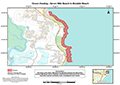 (PDF, 145.45 KB) |
Shelly Beach | The whole of the waters adjacent to the shoreline between Black Head and Ballina Head. | 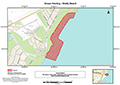 (PDF, 122.9 KB) |
Airforce Beach | The whole of the waters adjacent to the shoreline from the northern Evans River breakwall generally north for a distance of 400 metres (indicated by the 4WD access track onto the beach). | 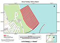 (PDF, 88.82 KB) |
Region 2 - Clarence
| Location | Description of waters | Location maps |
|---|---|---|
Woody Bay | The whole of the waters adjacent to the shoreline between the northeastern most extremity of Woody Head and the post marked “NSWF” on the foreshore (near the western end of the Woody Head camping ground) approximately 300 metres along the shoreline. |  (PDF, 164.63 KB) |
Turners Beach to Pippi Beach | The whole of the waters adjacent to the shoreline between the southern breakwall of the Clarence River and the vehicle access track on Pippi Beach (approximately 700 metres south of Yamba Point), including Turners Beach, Yamba Beach and Pippi Beach. The waters adjacent to Convent Beach are excluded from this prohibition. |  (PDF, 145.06 KB) |
Angourie Bay to Rocky Point (Lake Arragan entrance) | The whole of the waters adjacent to the shoreline between Angourie Point and Rocky Point (directly north of Red Cliff Beach) including Angourie Bay, Little Shelley Beach, Shelley Beach and Plumbago Beach. |  (PDF, 129.24 KB) |
Region 3 - North Coast
| Location | Description of waters | Location maps |
|---|---|---|
Park Beach | The whole of the waters adjacent to the shoreline between Macauleys Headland and a line drawn east from the shoreline passing through the northern-most point of Little Muttonbird Island (east of the entrance of Coffs Creek). | 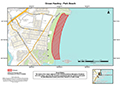 (PDF, 120.92 KB) |
Hungry Head | The whole of the waters adjacent to the shoreline from the southern training wall of the Bellingen River for a distance of 1km travelling generally south along the shoreline. | 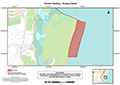 (PDF, 134.94 KB) |
Nambucca North Head | The whole of the waters adjacent to the shoreline between the northern end of Beilbys Beach and the southern end of Shelly Beach (Cliffy Point). | 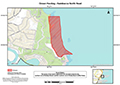 (PDF, 133.66 KB) |
Forster Beach | The whole of the waters adjacent to the shoreline from the southern side of the mouth of the Nambucca River for a distance of 1km travelling generally southwesterly along the shoreline. | 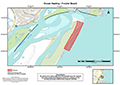 (PDF, 144.59 KB) |
Middle Beach and Grassy Beach | The whole of the waters adjacent to the shoreline between Scotts Head and Grassy Head. | 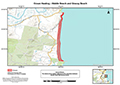 (PDF, 150.6 KB) |
Smoky Cape | The whole of the waters adjacent to the shoreline between the northwesternmost extremity of Laggers Point, following the shoreline to a point on South Smoky Beach 3km generally southwest from Smoky Cape (that is, adjacent to Black Rocks), including Little Bay, Gap Beach and North Smoky Beach. | 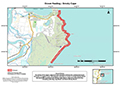 (PDF, 129.51 KB) |
Hat Head | The whole of the waters adjacent to the shoreline from the northernmost extremity of Korogoro Point, following the shoreline to a point on Killick Beach 3km generally southwest of the Jew Bite, including Gap Beach, O’Connors Beach and Third Beach. | 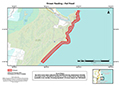 (PDF, 213.33 KB) |
Crescent Head | The whole of the waters adjacent to the shoreline from Little Nobby at the southern end of Killick Beach for a distance along that beach of 1km. See also Fisheries Management (Ocean Hauling on Killick Beach, Crescent Head - Fishing Closure) Notification 2023: The whole of the ocean waters adjacent to the shoreline from Little Nobby at Crescent Head (latitude 31° 11' 9.6288" S, longitude 152° 59' 2.835" E) travelling generally west along the shoreline to the mouth of Killick Creek, and then generally north along Killick Beach for a further distance along that beach of 1km (to the line of latitude at 31° 10' 40.8612" S, 152° 58' 30" E). | 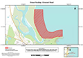 (PDF, 151.79 KB) |
North Shore Beach | The whole of the waters adjacent to the shoreline between the easternmost extremity of Point Plomer to a point on North Shore Beach 3.5km generally north of the wall travelling along the beach at Pelican Point. | 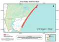 (PDF, 139.24 KB) |
Port Macquarie to Middle Rock Point | The whole of the waters adjacent to the shoreline between the southern wall of the entrance to the Hastings River and Middle Rock Point (south of Lighthouse Beach), including Town Beach, Oxleys Beach, Rocky Beach, Flynns Beach, Nobbys Beach, Shelly Beach, Miners Beach and Lighthouse Beach. | 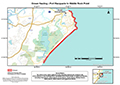 (PDF, 128.46 KB) |
Grants Beach | The whole of the waters adjacent to the shoreline between the northern wall of Camden Haven Inlet and a point on Grants Beach 1km along the beach. | 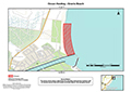 (PDF, 126.42 KB) |
Region 4 - Central
| Location | Description of waters | Location map |
|---|---|---|
Crowdy Head to Wallabi Point | The whole of the waters adjacent to the shoreline between the southwestern most point of Crowdy Head and Wallabi Point, including the entrance to the Manning River and Old Bar Beach (excluding between the northern breakwall at Harrington Inlet to Crowdy Head during the mullet travelling season). | 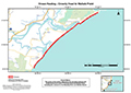 (PDF, 105.7 KB) |
Shelly Beach | The whole of the waters adjacent to the shoreline of Shelly Beach (north of Red Head and Black Head Bay). | 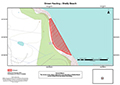 PDF, 76.1 KB) |
Wallis Lake entrance to Seven Mile Beach | The whole of the waters adjacent to the shoreline between the Wallis Lake entrance and the northern end of Seven Mile Beach, including Forster Beach, Pebbly Beach, One Mile Beach, Burgess Beach, Lobster Pot Beach and McBrides Beach. | 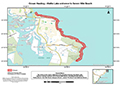 (PDF, 117.4 KB) |
Boomerang Beach to Blueys Beach | The whole of the waters adjacent to the shoreline between Pimply Rock and Blueys Beach. | 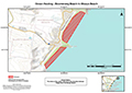 (PDF, 131.94 KB) |
Treachery Beach | The whole of the waters adjacent to the shoreline between Treachery Head and Yagon Gibber Headland. | 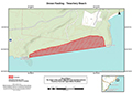 (PDF, 101.22 KB) |
Bennetts Beach | The whole of the waters adjacent to the shoreline for 500 metres on either side of Bennetts Beach Surf Club. | 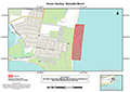 (PDF, 116.73 KB) |
Fingal Beach | The whole of the waters adjacent to the shoreline between Fingal Beach Surf Club and a point 1km generally northeast along the beach. | 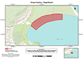 (PDF, 138.47 KB) |
Stockton Beach | The whole of the waters adjacent to the shoreline between the sewerage treatment works and a point 500 metres north of the Signa shipwreck (a distance of approximately 6.5km). | 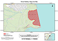 (PDF, 119.86 KB) |
Nobbys Head to Nine Mile Beach | The whole of the waters adjacent to the shoreline between the southern breakwall at Nobbys Head and the Waste Water Treatment Works at Belmont on Nine Mile Beach, including Nobbys Beach, Newcastle Beach, Bar Beach, Dixon Park Beach, Merewether Beach, Dudley Beach, Redhead Beach and approximately 5km of Nine Mile Beach. | 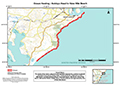 (PDF, 134.8 KB) |
Deep Cave Bay | The whole of the waters adjacent to the shoreline between the northern end of Moonee Beach and Flat Rocks Point. | (PDF, 121.76 KB) |
Frazer Beach | The whole of the waters adjacent to the shoreline between the easternmost point of Snapper Point and the easternmost point of Wybung Head. The area includes Bongon Beach, Frazer Beach, Gravelly Beach and Deadmans Beach. |  (PDF, 115.01 KB) |
Pebbley Beach | The whole of the waters adjacent to the shoreline between the easternmost point of Norah Head and the northernmost point of Soldiers Point. |  (PDF, 105.66 KB) |
Region 6 - Upper South Coast
| Location | Description of waters | Location maps |
|---|---|---|
Coalcliff Beach | The whole of the waters adjacent to the beach (known as Coalcliff Beach) north of Coalcliff Harbour. | 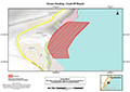 (PDF, 112.39 KB) |
Scarborough Beach to Wombarra Beach | The whole of the waters adjacent to the shoreline between the rocks at the northern end of Scarborough Beach to the pool at the southern end of Wombarra Beach, including Noony’s Gulf. | 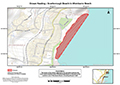 (PDF, 188.44 KB) |
Austinmer Beach | The whole of the waters adjacent to the shoreline between the southeasternmost extremity of Bell’s Point and the pool at the southern end of Austinmer Beach. | 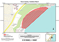 (PDF, 184.71 KB) |
Boyds Beach | The whole of the waters adjacent to the shoreline between the southernmost extremity of Minnamurra Point and the northwesternmost extremity end of Cathedral Rocks. | 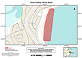 (PDF, 165.02 KB) |
Culburra Beach | The whole of the waters adjacent to the shoreline between the southern end of Greenwell Point and the southeastern end of Culburra Beach, including Tilbury Cove. | 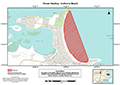 (PDF, 145.82 KB) |
Cudmirrah Beach to Monument Beach | The whole of the waters adjacent to the shoreline between the northern end of Cudmirrah Beach and the northern end of Monument Beach. | 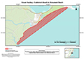 (PDF, 99.21 KB) |
Region 7 - Lower South Coast
| Location | Description of waters | Location maps |
|---|---|---|
Pebbly Beach | The whole of the waters adjacent to Pebbly Beach in Murramarang National Park. |  (PDF, 117.54 KB) |
Wimbie Beach to Rosedale Beach | The whole of the waters adjacent to the shoreline between the southern extremity of Wimbie Beach and the northern extremity of Rosedale Beach, including Circuit Beach, Lilli Pilli Beach, Mosquito Bay, Garden Bay, Malua Bay, Pretty Point Bay and McKenzies Beach. |  (PDF, 123.84 KB) |
Bengello Beach | The whole of the waters adjacent to the shoreline between the Moruya River breakwall and a point 500 metres generally northeast along Bengello Beach. |  (PDF, 121.46 KB) |
Tarandore Point to Tuross Head | The whole of the waters adjacent to the shoreline between Tarandore Point and Tuross Head, including One Tree Beach. | 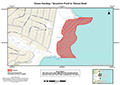 (PDF, 137.07 KB) |
Brou Beach (also known as Wilson Hall Beach) | The whole of the waters adjacent to the shoreline for 300 metres on each side of the first set of rocks south of the Lake Brou opening. | 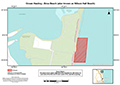 (PDF, 91.35 KB) |
Mummaga Head to Glasshouse Rocks | The whole of the waters adjacent to the shoreline between the northeasternmost extremity of Mummaga Head (Dalmeny) and Glasshouse Rocks (south of Narooma Beach), including Joshs Beach, Yabbara Beach, Duesburys Beach, Kianga Beach (except between 1 May and 30 June in each year, both dates inclusive), Carters Beach, Bar Beach and Narooma Beach. | 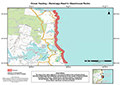 (PDF, 135.79 KB) |
Corunna Point to Boat Harbour Point | The whole of the waters adjacent to the shoreline between the southeasternmost extremity of Corunna Point and the southeasternmost extremity of Boat Harbour Point, including Mystery Bay. | 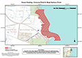 (PDF, 132.43 KB) |
Blue Point to Breakaway Beach | The whole of the waters adjacent to the shoreline between the northeasternmost extremity of Blue Point and the southern end of Breakaway Beach, including Jack Common Beach and Beares Beach. | 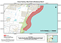 (PDF, 126.14 KB) |
Armonds Bay Beach to Murrah Head | The whole of the waters adjacent to the shoreline between the northern extremity of Armonds Bay and the southeastern extremity of Murrah Head. | 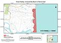 (PDF, 124.28 KB) |
Goalen Head to Bunga Head | The whole of the waters adjacent to the shoreline between the eastern extremity of Goalen Head and the eastern extremity of Bunga Head, including Bunga Beach. | 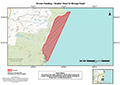 (PDF, 108.06 KB) |
Bengunnu Point to Picnic Beach | The whole of the waters adjacent to the shoreline between the eastern extremity of Bengunnu Point and the northern end of Picnic Beach. | 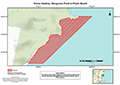 (PDF, 94.6 KB) |
Merimbula Beach | The whole of the waters adjacent to the shoreline between the northern extremity of Merimbula Beach and a point 500 metres south along that beach. | 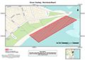 (PDF, 146.67 KB) |
